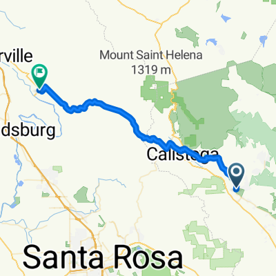
OYJ Calistoga (IA)
A cycling route starting in Deer Park, California, United States.
Overview
About this route
- -:--
- Duration
- 69.2 km
- Distance
- 1,065 m
- Ascent
- 1,088 m
- Descent
- ---
- Avg. speed
- 587 m
- Max. altitude
Route quality
Waytypes & surfaces along the route
Waytypes
Busy road
36.6 km
(53 %)
Road
29.8 km
(43 %)
Surfaces
Paved
4.5 km
(7 %)
Asphalt
4.5 km
(7 %)
Undefined
64.6 km
(93 %)
Route highlights
Points of interest along the route
Point of interest after 25 km
Rest Stop: Pope Valley Market
Continue with Bikemap
Use, edit, or download this cycling route
You would like to ride OYJ Calistoga (IA) or customize it for your own trip? Here is what you can do with this Bikemap route:
Free features
- Save this route as favorite or in collections
- Copy & plan your own version of this route
- Sync your route with Garmin or Wahoo
Premium features
Free trial for 3 days, or one-time payment. More about Bikemap Premium.
- Navigate this route on iOS & Android
- Export a GPX / KML file of this route
- Create your custom printout (try it for free)
- Download this route for offline navigation
Discover more Premium features.
Get Bikemap PremiumFrom our community
Other popular routes starting in Deer Park
- Deer Park Road
- Distance
- 11.2 km
- Ascent
- 556 m
- Descent
- 62 m
- Location
- Deer Park, California, United States
- OYJ Calistoga (L)
- Distance
- 46.7 km
- Ascent
- 555 m
- Descent
- 555 m
- Location
- Deer Park, California, United States
- Lake Hennessey
- Distance
- 18.7 km
- Ascent
- 344 m
- Descent
- 302 m
- Location
- Deer Park, California, United States
- Pope Valley - Lake Hennessey
- Distance
- 57 km
- Ascent
- 801 m
- Descent
- 815 m
- Location
- Deer Park, California, United States
- 1021 Deer Park Rd, Deer Park to 1235 Washington St, Calistoga
- Distance
- 14.2 km
- Ascent
- 275 m
- Descent
- 410 m
- Location
- Deer Park, California, United States
- 842 Meadowood Ln, Saint Helena to 254 Saint Helena Hwy S, Saint Helena
- Distance
- 4.8 km
- Ascent
- 8 m
- Descent
- 46 m
- Location
- Deer Park, California, United States
- Silverado Trail North 2970, St. Helena to Yount Street 6802, Yountville
- Distance
- 30.9 km
- Ascent
- 95 m
- Descent
- 130 m
- Location
- Deer Park, California, United States
- cold creek loop
- Distance
- 28.2 km
- Ascent
- 893 m
- Descent
- 542 m
- Location
- Deer Park, California, United States
Open it in the app