

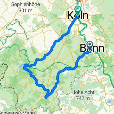
BRT2016-MO: Rund um den Flughafen - PSF des Radsportbezirk Mittelrhein-Süd beim BRT 2016 in Bonn - 100 km Strecke
A cycling route starting in Bonn, North Rhine-Westphalia, Germany.
Overview
About this route
BRT2016-MO: Rund um den Flughafen - 100 km
PSF (Pfeil-Such-Fahrt) des Radsportbezirk Mittelrhein-Süd beim BRT 2016 in Bonn
Alle weiteren Hinweise zu dieser Strecke -> hier anklicken
- -:--
- Duration
- 100.1 km
- Distance
- 289 m
- Ascent
- 289 m
- Descent
- ---
- Avg. speed
- ---
- Max. altitude

Route quality
Waytypes & surfaces along the route
Waytypes
Quiet road
24 km
(24 %)
Road
17 km
(17 %)
Surfaces
Paved
91.1 km
(91 %)
Asphalt
90.1 km
(90 %)
Paved (undefined)
1 km
(1 %)
Undefined
9 km
(9 %)
Route highlights
Points of interest along the route

Drinking water after 15.4 km
Kontrolle <b>Uckendorf</b>

Drinking water after 79.6 km
Kontrolle <b>Altenrath</b><br>wurde zweimal angesteuert<br>Ohne Navi war diese Kontrollstelle nicht ganz leicht zu finden, weil die Ausschilderung nach hier stark mangelhaft und irrführend war. Einige Fahrer der großen Runde fanden diese Kontrollstelle erst bei der 2. Anfahrt, weil sie vorher schon durch die Beschilderung in die große Schleife geleitet wurden.<br>Für Einheimische ausreichend, Gäste haben keine Chance, nur durch Pfeile geleitet zu werden.
Continue with Bikemap
Use, edit, or download this cycling route
You would like to ride BRT2016-MO: Rund um den Flughafen - PSF des Radsportbezirk Mittelrhein-Süd beim BRT 2016 in Bonn - 100 km Strecke or customize it for your own trip? Here is what you can do with this Bikemap route:
Free features
- Save this route as favorite or in collections
- Copy & plan your own version of this route
- Split it into stages to create a multi-day tour
- Sync your route with Garmin or Wahoo
Premium features
Free trial for 3 days, or one-time payment. More about Bikemap Premium.
- Navigate this route on iOS & Android
- Export a GPX / KML file of this route
- Create your custom printout (try it for free)
- Download this route for offline navigation
Discover more Premium features.
Get Bikemap PremiumFrom our community
Other popular routes starting in Bonn
 Bonn - Ahrquelle - Rursee - Köln
- Distance
- 154 km
- Ascent
- 987 m
- Descent
- 1,006 m
- Location
- Bonn, North Rhine-Westphalia, Germany
 BRT2016-FR: An Rhein und Sieg - PSF des Radsportbezirk Mittelrhein-Süd beim BRT 2016 in Bonn - 76 km Strecke
- Distance
- 74.9 km
- Ascent
- 509 m
- Descent
- 509 m
- Location
- Bonn, North Rhine-Westphalia, Germany
 Bonn - Eifel - Westerwald - Bonn
- Distance
- 189.7 km
- Ascent
- 1,343 m
- Descent
- 1,341 m
- Location
- Bonn, North Rhine-Westphalia, Germany
 Bonn - Stadt Blankenberg
- Distance
- 79.5 km
- Ascent
- 846 m
- Descent
- 846 m
- Location
- Bonn, North Rhine-Westphalia, Germany
 kleine McDrive-Runde (Ittenbach)
- Distance
- 40.7 km
- Ascent
- 437 m
- Descent
- 437 m
- Location
- Bonn, North Rhine-Westphalia, Germany
 Flach um Bonn
- Distance
- 56.6 km
- Ascent
- 186 m
- Descent
- 186 m
- Location
- Bonn, North Rhine-Westphalia, Germany
 Auf den Feldern zwischen Köln und Troisdorf
- Distance
- 29.5 km
- Ascent
- 23 m
- Descent
- 24 m
- Location
- Bonn, North Rhine-Westphalia, Germany
 Drachenfels-Milchhäuschen
- Distance
- 38.8 km
- Ascent
- 588 m
- Descent
- 585 m
- Location
- Bonn, North Rhine-Westphalia, Germany
Open it in the app