
STGlatterboden
A cycling route starting in Irdning, Styria, Austria.
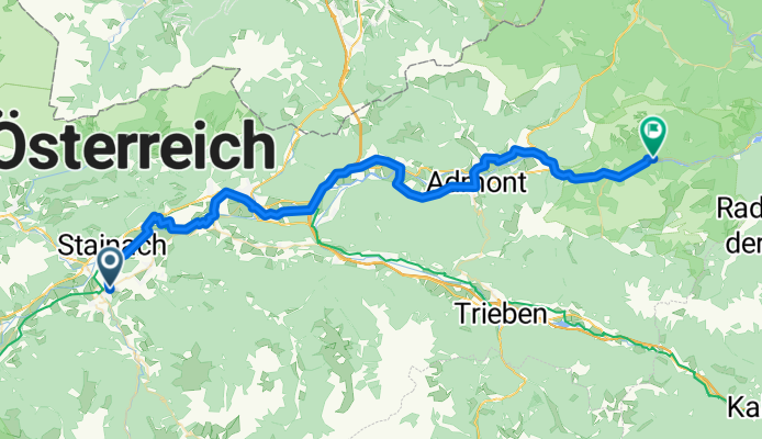
Overview
About this route
Glatterboden Nationalpark, Kloster Admond ca 40 km
über Liezen (Enstal östlich) R7
Bfh. Glatterboden, ca. 57 km
Richtung Irdning.
56 km eben 190 hm
- -:--
- Duration
- 57 km
- Distance
- 179 m
- Ascent
- 277 m
- Descent
- ---
- Avg. speed
- ---
- Max. altitude

Route quality
Waytypes & surfaces along the route
Waytypes
Cycleway
16.5 km
(29 %)
Busy road
15.3 km
(27 %)
Surfaces
Paved
30.9 km
(54 %)
Unpaved
2.4 km
(4 %)
Asphalt
29.3 km
(51 %)
Gravel
2.4 km
(4 %)
Route highlights
Points of interest along the route
Photo after 39.2 km
Kloster Edmond
Continue with Bikemap
Use, edit, or download this cycling route
You would like to ride STGlatterboden or customize it for your own trip? Here is what you can do with this Bikemap route:
Free features
- Save this route as favorite or in collections
- Copy & plan your own version of this route
- Sync your route with Garmin or Wahoo
Premium features
Free trial for 3 days, or one-time payment. More about Bikemap Premium.
- Navigate this route on iOS & Android
- Export a GPX / KML file of this route
- Create your custom printout (try it for free)
- Download this route for offline navigation
Discover more Premium features.
Get Bikemap PremiumFrom our community
Other popular routes starting in Irdning
 Trautenfels-Bad Mitterndorf
- Distance
- 15 km
- Ascent
- 246 m
- Descent
- 85 m
- Location
- Irdning, Styria, Austria
 Irdning Pruggern
- Distance
- 50.6 km
- Ascent
- 252 m
- Descent
- 252 m
- Location
- Irdning, Styria, Austria
 Ennstalrunde 2
- Distance
- 49.5 km
- Ascent
- 269 m
- Descent
- 277 m
- Location
- Irdning, Styria, Austria
 Irdning <-> Planneralm
- Distance
- 18.4 km
- Ascent
- 1,134 m
- Descent
- 230 m
- Location
- Irdning, Styria, Austria
 STGlatterboden
- Distance
- 57 km
- Ascent
- 179 m
- Descent
- 277 m
- Location
- Irdning, Styria, Austria
 Grimming Runde
- Distance
- 48.5 km
- Ascent
- 916 m
- Descent
- 917 m
- Location
- Irdning, Styria, Austria
 STPlanneralm
- Distance
- 18.1 km
- Ascent
- 967 m
- Descent
- 44 m
- Location
- Irdning, Styria, Austria
 Spechtensee Runde
- Distance
- 28.9 km
- Ascent
- 601 m
- Descent
- 602 m
- Location
- Irdning, Styria, Austria
Open it in the app