

II Morciencuentros
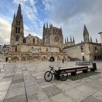
BCB. II Morciencuentros 1. Burgos-Mecerreyes
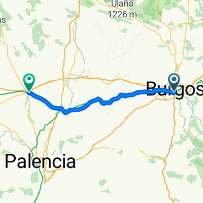
A cycling route starting in Burgos, Castille and León, Spain.
Overview
About this route
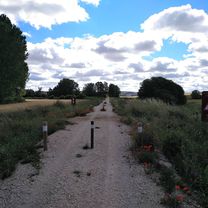
Transition stage from Burgos city to the southeast of the province. Long but mostly flat.
From the MEH, departing via the Santander-Mediterranean Greenway to Cojobar. Then we look for the Revillaruz path and from there, crossing the Ausines River, we continue also by path to the Quintanilla neighborhood, in Los Ausines.
Passing the monastery, climb to the first path on the left, follow the Camino del Cid to Modubar de San Cybrian and from there head out onto the road toward Revilla del Campo where we'll eat.
From there straight ahead passing most of the villages of Lara until Cuevas de San Clemente where we have to cross the national road toward Mecerreyes.
There is an alternative from Quintanalara to Cubillo del César. It is a track and shortens a few kilometers, but you have to climb a bit.
- -:--
- Duration
- 60.3 km
- Distance
- 414 m
- Ascent
- 288 m
- Descent
- ---
- Avg. speed
- ---
- Max. altitude

Part of
3 stages
Route quality
Waytypes & surfaces along the route
Waytypes
Road
30.7 km
(51 %)
Cycleway
10.2 km
(17 %)
Surfaces
Paved
42.2 km
(70 %)
Unpaved
8.4 km
(14 %)
Asphalt
38.6 km
(64 %)
Gravel
5.4 km
(9 %)
Continue with Bikemap
Use, edit, or download this cycling route
You would like to ride BCB. II Morciencuentros 1. Burgos-Mecerreyes or customize it for your own trip? Here is what you can do with this Bikemap route:
Free features
- Save this route as favorite or in collections
- Copy & plan your own version of this route
- Sync your route with Garmin or Wahoo
Premium features
Free trial for 3 days, or one-time payment. More about Bikemap Premium.
- Navigate this route on iOS & Android
- Export a GPX / KML file of this route
- Create your custom printout (try it for free)
- Download this route for offline navigation
Discover more Premium features.
Get Bikemap PremiumFrom our community
Other popular routes starting in Burgos
 Calle de San Pablo, Burgos to Burgos
- Distance
- 11.4 km
- Ascent
- 39 m
- Descent
- 42 m
- Location
- Burgos, Castille and León, Spain
 Anormalidad 0.1
- Distance
- 45.8 km
- Ascent
- 242 m
- Descent
- 242 m
- Location
- Burgos, Castille and León, Spain
 2025. 1 nap El Camino
- Distance
- 86.3 km
- Ascent
- 535 m
- Descent
- 565 m
- Location
- Burgos, Castille and León, Spain
 Jakobsweg 5. 29.8.05 Carrion de los Condes
- Distance
- 98.1 km
- Ascent
- 476 m
- Descent
- 536 m
- Location
- Burgos, Castille and León, Spain
 Camino Natural Santander-Mediterráneo hasta Peñahorada
- Distance
- 20.4 km
- Ascent
- 129 m
- Descent
- 85 m
- Location
- Burgos, Castille and León, Spain
 BCB. Ruta Día de las Vías Verdes 2017. Versión fácil
- Distance
- 47.4 km
- Ascent
- 198 m
- Descent
- 197 m
- Location
- Burgos, Castille and León, Spain
 Inmunización 2.1 - Viajando al Paleolítico.
- Distance
- 52.8 km
- Ascent
- 515 m
- Descent
- 516 m
- Location
- Burgos, Castille and León, Spain
 Anormalidad 2.0.1 - Sanctuary regresando por carretera.
- Distance
- 43.6 km
- Ascent
- 323 m
- Descent
- 321 m
- Location
- Burgos, Castille and León, Spain
Open it in the app