

Bellreguard - Pla de Corrals - Llutxent - Bellreguard (BTT) GPS
A cycling route starting in Bellreguard, Valencia, Spain.
Overview
About this route
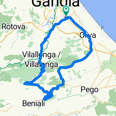
BTT outing with asphalt and dirt.
*Dirt path from the top climb of Barx to Puig Mola. *Climb from Pla de Corrals to Pinet, 3 km of demanding dirt track in good condition. *From Llutxent to Lloc Nou, road and dirt path with sections of asphalt. *One must cross the Vernissa river before reaching Lloc Nou on a bicycle. *On this route from Lloc Nou to Bellreguard via the service road of the Albaida highway. It is possible to have a dirt path from Verniprens until after Rotova. Duration around 4 hours.
- -:--
- Duration
- 44.4 km
- Distance
- 908 m
- Ascent
- 907 m
- Descent
- ---
- Avg. speed
- ---
- Max. altitude

Route highlights
Points of interest along the route
Point of interest after 25.2 km
Esmorzar
Continue with Bikemap
Use, edit, or download this cycling route
You would like to ride Bellreguard - Pla de Corrals - Llutxent - Bellreguard (BTT) GPS or customize it for your own trip? Here is what you can do with this Bikemap route:
Free features
- Save this route as favorite or in collections
- Copy & plan your own version of this route
- Sync your route with Garmin or Wahoo
Premium features
Free trial for 3 days, or one-time payment. More about Bikemap Premium.
- Navigate this route on iOS & Android
- Export a GPX / KML file of this route
- Create your custom printout (try it for free)
- Download this route for offline navigation
Discover more Premium features.
Get Bikemap PremiumFrom our community
Other popular routes starting in Bellreguard
 L' Orxa llarga MTB
- Distance
- 56.8 km
- Ascent
- 1,089 m
- Descent
- 1,098 m
- Location
- Bellreguard, Valencia, Spain
 Collado Terrateig BTT
- Distance
- 49.9 km
- Ascent
- 675 m
- Descent
- 672 m
- Location
- Bellreguard, Valencia, Spain
 BELLREGUARD CULLERA TAVERNES SIMAT BARX GANDIA BELLREGUARD
- Distance
- 74.7 km
- Ascent
- 412 m
- Descent
- 412 m
- Location
- Bellreguard, Valencia, Spain
 Bellreguard - L'Orxa per Llacuna i La Safor (BTT)
- Distance
- 49.3 km
- Ascent
- 1,418 m
- Descent
- 1,361 m
- Location
- Bellreguard, Valencia, Spain
 GANDIA - ALMANSA- ENTRENE ICAN 21
- Distance
- 110.4 km
- Ascent
- 1,076 m
- Descent
- 392 m
- Location
- Bellreguard, Valencia, Spain
 C.C. Bellreguard 13ª C etapa del calendari de rutes
- Distance
- 83.5 km
- Ascent
- 746 m
- Descent
- 747 m
- Location
- Bellreguard, Valencia, Spain
 C.C. Bellreguard Marxa Bellreguard - Biar - Bellreguard ANADA
- Distance
- 130.1 km
- Ascent
- 1,567 m
- Descent
- 890 m
- Location
- Bellreguard, Valencia, Spain
 Salida Benirrama BTT
- Distance
- 48.2 km
- Ascent
- 759 m
- Descent
- 759 m
- Location
- Bellreguard, Valencia, Spain
Open it in the app