
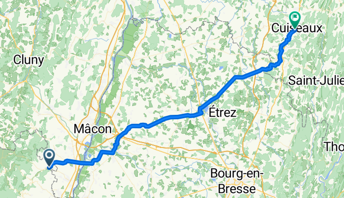
Juliénas -Cuiseaux
A cycling route starting in La Chapelle-de-Guinchay, Bourgogne-Franche-Comté, France.
Overview
About this route
Von Juliénas durch die £Bresse nach Cuiseaux
- -:--
- Duration
- 71.8 km
- Distance
- 336 m
- Ascent
- 327 m
- Descent
- ---
- Avg. speed
- ---
- Max. altitude
Route quality
Waytypes & surfaces along the route
Waytypes
Quiet road
29.6 km
(41 %)
Busy road
24.3 km
(34 %)
Surfaces
Paved
35.7 km
(50 %)
Unpaved
1.9 km
(3 %)
Asphalt
35.7 km
(50 %)
Ground
1.2 km
(2 %)
Continue with Bikemap
Use, edit, or download this cycling route
You would like to ride Juliénas -Cuiseaux or customize it for your own trip? Here is what you can do with this Bikemap route:
Free features
- Save this route as favorite or in collections
- Copy & plan your own version of this route
- Sync your route with Garmin or Wahoo
Premium features
Free trial for 3 days, or one-time payment. More about Bikemap Premium.
- Navigate this route on iOS & Android
- Export a GPX / KML file of this route
- Create your custom printout (try it for free)
- Download this route for offline navigation
Discover more Premium features.
Get Bikemap PremiumFrom our community
Other popular routes starting in La Chapelle-de-Guinchay
 Veloreisli 2021_2
- Distance
- 78 km
- Ascent
- 1,514 m
- Descent
- 1,517 m
- Location
- La Chapelle-de-Guinchay, Bourgogne-Franche-Comté, France
 Macon Süd - Genf
- Distance
- 311.4 km
- Ascent
- 575 m
- Descent
- 370 m
- Location
- La Chapelle-de-Guinchay, Bourgogne-Franche-Comté, France
 loz-st syphrin
- Distance
- 201 km
- Ascent
- 1,920 m
- Descent
- 1,557 m
- Location
- La Chapelle-de-Guinchay, Bourgogne-Franche-Comté, France
 Juliénas -Cuiseaux
- Distance
- 71.8 km
- Ascent
- 336 m
- Descent
- 327 m
- Location
- La Chapelle-de-Guinchay, Bourgogne-Franche-Comté, France
 Loop into Ain, back via Thoissey
- Distance
- 43.6 km
- Ascent
- 195 m
- Descent
- 225 m
- Location
- La Chapelle-de-Guinchay, Bourgogne-Franche-Comté, France
 De D17E 2080, Saint-Amour-Bellevue à Champ de la Lié 746, Varennes-lès-Mâcon
- Distance
- 8.1 km
- Ascent
- 91 m
- Descent
- 198 m
- Location
- La Chapelle-de-Guinchay, Bourgogne-Franche-Comté, France
 circuit 1
- Distance
- 58 km
- Ascent
- 1,271 m
- Descent
- 1,271 m
- Location
- La Chapelle-de-Guinchay, Bourgogne-Franche-Comté, France
 Out to Pizay, Truges, back via Chiroubles and Fleurie
- Distance
- 40.9 km
- Ascent
- 743 m
- Descent
- 760 m
- Location
- La Chapelle-de-Guinchay, Bourgogne-Franche-Comté, France
Open it in the app