

Forumsrunde 5311
A cycling route starting in Börgerende-Rethwisch, Mecklenburg-Vorpommern, Germany.
Overview
About this route
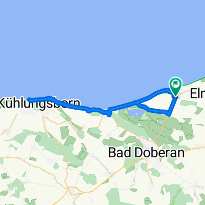
<p>Forumsrunde Team 5311 - October 2009. Coastal route between Wilhelmshöhe and Signalberg Bastorf through ghost forests, seaside resorts and with a sporting challenge up to the lighthouse.</p>
Translated, show original (German)- -:--
- Duration
- 64.3 km
- Distance
- 234 m
- Ascent
- 222 m
- Descent
- ---
- Avg. speed
- 75 m
- Max. altitude

Route quality
Waytypes & surfaces along the route
Waytypes
Path
28.3 km
(44 %)
Quiet road
21.8 km
(34 %)
Surfaces
Paved
20.6 km
(32 %)
Unpaved
25.7 km
(40 %)
Asphalt
19.9 km
(31 %)
Gravel
12.9 km
(20 %)
Continue with Bikemap
Use, edit, or download this cycling route
You would like to ride Forumsrunde 5311 or customize it for your own trip? Here is what you can do with this Bikemap route:
Free features
- Save this route as favorite or in collections
- Copy & plan your own version of this route
- Sync your route with Garmin or Wahoo
Premium features
Free trial for 3 days, or one-time payment. More about Bikemap Premium.
- Navigate this route on iOS & Android
- Export a GPX / KML file of this route
- Create your custom printout (try it for free)
- Download this route for offline navigation
Discover more Premium features.
Get Bikemap PremiumFrom our community
Other popular routes starting in Börgerende-Rethwisch
 Rücktour Ostsee 2011
- Distance
- 300.7 km
- Ascent
- 280 m
- Descent
- 239 m
- Location
- Börgerende-Rethwisch, Mecklenburg-Vorpommern, Germany
 2018 Nienhagen-DJH Darß
- Distance
- 65.6 km
- Ascent
- 103 m
- Descent
- 112 m
- Location
- Börgerende-Rethwisch, Mecklenburg-Vorpommern, Germany
 Forumsrunde 5311
- Distance
- 64.3 km
- Ascent
- 234 m
- Descent
- 222 m
- Location
- Börgerende-Rethwisch, Mecklenburg-Vorpommern, Germany
 Nienhagen Warnemünde
- Distance
- 10.3 km
- Ascent
- 51 m
- Descent
- 58 m
- Location
- Börgerende-Rethwisch, Mecklenburg-Vorpommern, Germany
 Ostsee-Radweg Tag 4.
- Distance
- 77.4 km
- Ascent
- 53 m
- Descent
- 49 m
- Location
- Börgerende-Rethwisch, Mecklenburg-Vorpommern, Germany
 Nienhagen-Kühlunsborn-Nienhagen
- Distance
- 33.5 km
- Ascent
- 73 m
- Descent
- 71 m
- Location
- Börgerende-Rethwisch, Mecklenburg-Vorpommern, Germany
 Am Meer 1, Nienhagen nach Doberaner Straße 32A, Kühlungsborn
- Distance
- 15.8 km
- Ascent
- 41 m
- Descent
- 43 m
- Location
- Börgerende-Rethwisch, Mecklenburg-Vorpommern, Germany
 Börgerende-Bargeshagen-Hütten-Reddelich-Wittenbeck-Heiligendamm-Börgerende
- Distance
- 45.9 km
- Ascent
- 169 m
- Descent
- 169 m
- Location
- Börgerende-Rethwisch, Mecklenburg-Vorpommern, Germany
Open it in the app