
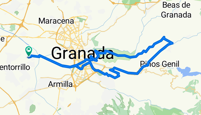
EXPERIMENTADOS : Purchil-Llano Perdiz-Dudar-Balcón Genil-Purchil
A cycling route starting in Cúllar-Vega, Andalusia, Spain.
Overview
About this route
Salida del Ayuntamiento subiendo al Llano de la Perdiz direccion a Dudar bajando por el Genil y por último subida a Balcón del Genil para llegar a Purchil
- -:--
- Duration
- 45.9 km
- Distance
- 741 m
- Ascent
- 738 m
- Descent
- ---
- Avg. speed
- ---
- Max. altitude
Continue with Bikemap
Use, edit, or download this cycling route
You would like to ride EXPERIMENTADOS : Purchil-Llano Perdiz-Dudar-Balcón Genil-Purchil or customize it for your own trip? Here is what you can do with this Bikemap route:
Free features
- Save this route as favorite or in collections
- Copy & plan your own version of this route
- Sync your route with Garmin or Wahoo
Premium features
Free trial for 3 days, or one-time payment. More about Bikemap Premium.
- Navigate this route on iOS & Android
- Export a GPX / KML file of this route
- Create your custom printout (try it for free)
- Download this route for offline navigation
Discover more Premium features.
Get Bikemap PremiumFrom our community
Other popular routes starting in Cúllar-Vega
 vegas del genil-hospital inmaculada
- Distance
- 15.2 km
- Ascent
- 427 m
- Descent
- 362 m
- Location
- Cúllar-Vega, Andalusia, Spain
 EXPERIMENTADOS : Purchil-Llano Perdiz-Dudar-Balcón Genil-Purchil
- Distance
- 45.9 km
- Ascent
- 741 m
- Descent
- 738 m
- Location
- Cúllar-Vega, Andalusia, Spain
 Dehesa de Santa Fé
- Distance
- 21.3 km
- Ascent
- 260 m
- Descent
- 259 m
- Location
- Cúllar-Vega, Andalusia, Spain
 Ambroz - Granada - Ambroz
- Distance
- 13.3 km
- Ascent
- 49 m
- Descent
- 50 m
- Location
- Cúllar-Vega, Andalusia, Spain
 PURCHIL-FUENTE HERVIDERO-MONACHIL-CENES-PURCHIL
- Distance
- 50.1 km
- Ascent
- 1,019 m
- Descent
- 1,019 m
- Location
- Cúllar-Vega, Andalusia, Spain
 SUAVES:Purchil-LLano Perdiz-Abadía Sacromonte-Purchil
- Distance
- 31.6 km
- Ascent
- 469 m
- Descent
- 469 m
- Location
- Cúllar-Vega, Andalusia, Spain
 ambroz nerja
- Distance
- 96.5 km
- Ascent
- 1,156 m
- Descent
- 1,758 m
- Location
- Cúllar-Vega, Andalusia, Spain
 PURCHIL-TORREON_ALBOLOTE-SIERRA_ELVIRA-PURCHIL
- Distance
- 35.7 km
- Ascent
- 343 m
- Descent
- 344 m
- Location
- Cúllar-Vega, Andalusia, Spain
Open it in the app