

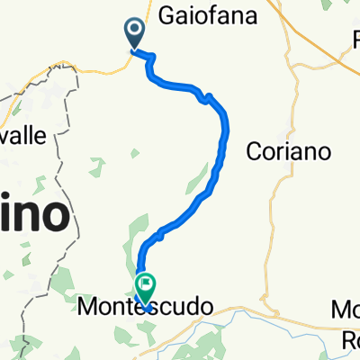
Dogana-Città di San Marino
A cycling route starting in Cerasolo, Emilia-Romagna, Italy.
Overview
About this route
Salita da Dogana, alle porte della Città di San Marino
- -:--
- Duration
- 12.7 km
- Distance
- 662 m
- Ascent
- 68 m
- Descent
- ---
- Avg. speed
- ---
- Max. altitude
Route quality
Waytypes & surfaces along the route
Waytypes
Road
5.9 km
(46 %)
Quiet road
4.2 km
(33 %)
Surfaces
Paved
8.8 km
(69 %)
Asphalt
8.4 km
(66 %)
Paving stones
0.4 km
(3 %)
Undefined
4 km
(31 %)
Continue with Bikemap
Use, edit, or download this cycling route
You would like to ride Dogana-Città di San Marino or customize it for your own trip? Here is what you can do with this Bikemap route:
Free features
- Save this route as favorite or in collections
- Copy & plan your own version of this route
- Sync your route with Garmin or Wahoo
Premium features
Free trial for 3 days, or one-time payment. More about Bikemap Premium.
- Navigate this route on iOS & Android
- Export a GPX / KML file of this route
- Create your custom printout (try it for free)
- Download this route for offline navigation
Discover more Premium features.
Get Bikemap PremiumFrom our community
Other popular routes starting in Cerasolo
 Cerasolo-P.Grillo-Sogliano-P.Berni-Cerasolo
- Distance
- 76.7 km
- Ascent
- 1,216 m
- Descent
- 1,284 m
- Location
- Cerasolo, Emilia-Romagna, Italy
 abbbbab bbad
- Distance
- 59.6 km
- Ascent
- 1,753 m
- Descent
- 1,108 m
- Location
- Cerasolo, Emilia-Romagna, Italy
 3) Cerasolo Ausa - Russi
- Distance
- 77.2 km
- Ascent
- 83 m
- Descent
- 124 m
- Location
- Cerasolo, Emilia-Romagna, Italy
 Carpegna
- Distance
- 89.5 km
- Ascent
- 1,372 m
- Descent
- 1,375 m
- Location
- Cerasolo, Emilia-Romagna, Italy
 Cerasolo-Croce-M.Altavellio-Tavoleto-Morciano-Cerasolo
- Distance
- 80.2 km
- Ascent
- 1,231 m
- Descent
- 1,326 m
- Location
- Cerasolo, Emilia-Romagna, Italy
 Cerasolo-Montegridolfo-Tavullia-Cerasolo
- Distance
- 84.9 km
- Ascent
- 1,085 m
- Descent
- 1,166 m
- Location
- Cerasolo, Emilia-Romagna, Italy
 Giro semplice in Montescudo
- Distance
- 12.7 km
- Ascent
- 445 m
- Descent
- 109 m
- Location
- Cerasolo, Emilia-Romagna, Italy
 Recovered Route
- Distance
- 29.1 km
- Ascent
- 356 m
- Descent
- 342 m
- Location
- Cerasolo, Emilia-Romagna, Italy
Open it in the app