

Balatonkerülés (4 nap)
A cycling route starting in Balatonszárszó, Somogy County, Hungary.
Overview
About this route
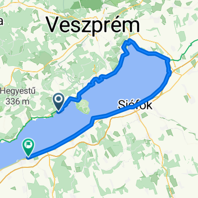
1st day: Balatonszemes - Balatonaliga /41 km/
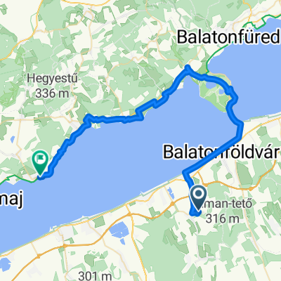
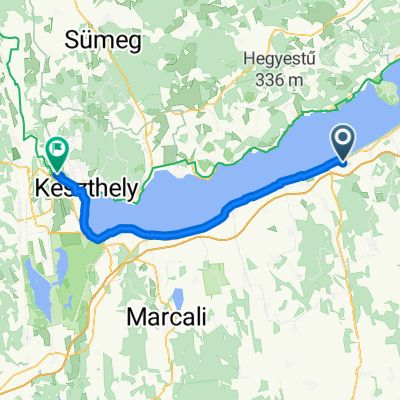
2nd day: Balatonaliga - Fövenyes (58 km) /99 km/ 3rd day: Fövenyes - Keszthely (60 km) /159 km/ 4th day: Keszthely - Balatonszemes (50 km) /209 km/- -:--
- Duration
- 209.2 km
- Distance
- 273 m
- Ascent
- 270 m
- Descent
- ---
- Avg. speed
- ---
- Max. altitude

Route quality
Waytypes & surfaces along the route
Waytypes
Cycleway
75.3 km
(36 %)
Quiet road
62.8 km
(30 %)
Surfaces
Paved
194.5 km
(93 %)
Asphalt
194.5 km
(93 %)
Undefined
14.6 km
(7 %)
Route highlights
Points of interest along the route
Point of interest after 0 km
Balatonszemes Lídó Camping
Point of interest after 41.7 km
Balatonaliga Camping
Point of interest after 97.7 km
Fövenyes Camping
Point of interest after 157.2 km
Keszthely Camping
Continue with Bikemap
Use, edit, or download this cycling route
You would like to ride Balatonkerülés (4 nap) or customize it for your own trip? Here is what you can do with this Bikemap route:
Free features
- Save this route as favorite or in collections
- Copy & plan your own version of this route
- Split it into stages to create a multi-day tour
- Sync your route with Garmin or Wahoo
Premium features
Free trial for 3 days, or one-time payment. More about Bikemap Premium.
- Navigate this route on iOS & Android
- Export a GPX / KML file of this route
- Create your custom printout (try it for free)
- Download this route for offline navigation
Discover more Premium features.
Get Bikemap PremiumFrom our community
Other popular routes starting in Balatonszárszó
 Balaton 1/2
- Distance
- 101.2 km
- Ascent
- 346 m
- Descent
- 342 m
- Location
- Balatonszárszó, Somogy County, Hungary
 Balatonőszödi látogatás - Böszme túra
- Distance
- 6.5 km
- Ascent
- 47 m
- Descent
- 49 m
- Location
- Balatonszárszó, Somogy County, Hungary
 Balaton 1
- Distance
- 50.1 km
- Ascent
- 276 m
- Descent
- 313 m
- Location
- Balatonszárszó, Somogy County, Hungary
 Délután
- Distance
- 18.6 km
- Ascent
- 27 m
- Descent
- 29 m
- Location
- Balatonszárszó, Somogy County, Hungary
 Rajk László utca 5, Balatonszemes - Tompa Mihály utca 23, Balatonszemes
- Distance
- 51.2 km
- Ascent
- 111 m
- Descent
- 158 m
- Location
- Balatonszárszó, Somogy County, Hungary
 Balatonkerülés (4 nap)
- Distance
- 209.2 km
- Ascent
- 273 m
- Descent
- 270 m
- Location
- Balatonszárszó, Somogy County, Hungary
 Rajk László utca 6, Balatonszemes - Rajk László utca 6, Balatonszemes
- Distance
- 48 km
- Ascent
- 139 m
- Descent
- 184 m
- Location
- Balatonszárszó, Somogy County, Hungary
 Gyenesdiás - Tihany
- Distance
- 60.3 km
- Ascent
- 120 m
- Descent
- 111 m
- Location
- Balatonszárszó, Somogy County, Hungary
Open it in the app