

Feininger Radtour
A cycling route starting in Bansin, Mecklenburg-Vorpommern, Germany.
Overview
About this route
By bike following the tracks of Lyonel Feininger
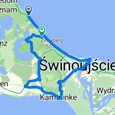
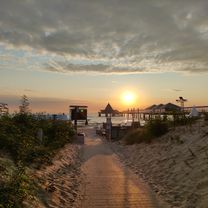
It connects 80 artistic motifs at a total of 40 stations over a total length of 56 kilometres: the Lyonel-Feininger circular route on the island of Usedom. The German-American painter Lyonel Feininger was an avid cyclist. Since he lived in Germany, he regularly bought the latest racing bike model and covered thousands of kilometres every year. On 17 May 1908 he was on the island of Usedom for the first time. Until 1912 he explored the area on his Cleveland Ohio from Heringsdorf, Neppermin or Benz and was always looking for new motifs. 100 years later, the idea arose to discover all of Feininger’s painting locations on Usedom, to map them and create a tourist cycling route – the “Lyonel-Feininger Tour”. From letters to his wife Julia, it is known that he stayed in Neppermin. There he painted signs with boat numbers to please the fishermen. Here and in many other places, his “nature notes” were created, drawings that often served as the basis for a painting. Examples are “Moonrise in Neppermin” or a circus scene on the village square in Balm. His excursions also took Feininger to the neighbouring Benz. On the way he painted the road with the then freshly planted avenue trees. In the Benz church tower he found a motif that fascinated him until the end of his life. Even shortly before his death in New York, in 1955, he created a watercolour of the church. The drawing of the Benz Dutch windmill is now owned by the Rockefeller family and represents the first pictorial depiction of the present-day monument. The Lyonel-Feininger circular route, opened in 2009, leads through Mellenthin, Balm, Neppermin, Benz, Sallenthin, Bansin, Heringsdorf, Ahlbeck, Świnoujście, Zirchow, Korswandt, Gothen, and Neuhof. White-blue signs show cyclists and art lovers the way following the footsteps of the German-American painter. The individual painting locations are marked with bronze plaques. (cloned from route 2238901) (cloned from route 2238902) (cloned from route 3421343)- -:--
- Duration
- 41.1 km
- Distance
- 180 m
- Ascent
- 180 m
- Descent
- ---
- Avg. speed
- ---
- Max. altitude
Route quality
Waytypes & surfaces along the route
Waytypes
Road
18.9 km
(46 %)
Track
14.4 km
(35 %)
Surfaces
Paved
26.7 km
(65 %)
Unpaved
6.6 km
(16 %)
Asphalt
20.5 km
(50 %)
Concrete
6.2 km
(15 %)
Continue with Bikemap
Use, edit, or download this cycling route
You would like to ride Feininger Radtour or customize it for your own trip? Here is what you can do with this Bikemap route:
Free features
- Save this route as favorite or in collections
- Copy & plan your own version of this route
- Sync your route with Garmin or Wahoo
Premium features
Free trial for 3 days, or one-time payment. More about Bikemap Premium.
- Navigate this route on iOS & Android
- Export a GPX / KML file of this route
- Create your custom printout (try it for free)
- Download this route for offline navigation
Discover more Premium features.
Get Bikemap PremiumFrom our community
Other popular routes starting in Bansin
 Seepark 24, Heringsdorf nach Seepark 23, Heringsdorf
- Distance
- 16.3 km
- Ascent
- 81 m
- Descent
- 35 m
- Location
- Bansin, Mecklenburg-Vorpommern, Germany
 Seepark 24, Heringsdorf nach Kanalstraße 1, Heringsdorf
- Distance
- 2.2 km
- Ascent
- 60 m
- Descent
- 18 m
- Location
- Bansin, Mecklenburg-Vorpommern, Germany
 Seepark 25, Heringsdorf nach Seepark 23, Heringsdorf
- Distance
- 19.9 km
- Ascent
- 84 m
- Descent
- 149 m
- Location
- Bansin, Mecklenburg-Vorpommern, Germany
 Seepark 23, Heringsdorf nach Maxim-Gorki-Straße 37, Heringsdorf
- Distance
- 1.3 km
- Ascent
- 37 m
- Descent
- 3 m
- Location
- Bansin, Mecklenburg-Vorpommern, Germany
 Radfahren Usedom
- Distance
- 48.8 km
- Ascent
- 107 m
- Descent
- 112 m
- Location
- Bansin, Mecklenburg-Vorpommern, Germany
 Große Feininger Tour
- Distance
- 41.2 km
- Ascent
- 191 m
- Descent
- 179 m
- Location
- Bansin, Mecklenburg-Vorpommern, Germany
 Seepark 25, Heringsdorf nach Seepark 23, Heringsdorf
- Distance
- 16.3 km
- Ascent
- 23 m
- Descent
- 3 m
- Location
- Bansin, Mecklenburg-Vorpommern, Germany
 Seestraße, Heringsdorf nach Koserow
- Distance
- 16.5 km
- Ascent
- 127 m
- Descent
- 144 m
- Location
- Bansin, Mecklenburg-Vorpommern, Germany
Open it in the app