

Rund um West-Berlin (Mauerweg RR)
A cycling route starting in Plänterwald, State of Berlin, Germany.
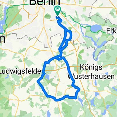
Overview
About this route
In Lichtenrade, you can shorten the route well by not turning left into Kirchhainer Damm but going straight through Horstwalder Straße. The very brave can also turn right into Roter Dudel onto a field path, which is indeed secured by a half-barrier level crossing.
In Zehlendorf/Düppel/Dreilinden, the Mauerweg (Königsweg) is not suitable for RR, so the southern bypass. The detours along the Stammbahn are partially unsuitable for any bike - but you can certainly push a few meters. It is especially worthwhile here...
In Griebnitzsee, some antisocial landowners have closed the riverside path, so you probably have to take a detour. Rosa-Luxemburg-Str has a nice name, is low in traffic, and you also get to enjoy a nice hill.
(IMHO, the city of Potsdam should counter the possibly unlawful closure of the riverside path with the sale of Karl-Marx-Str to an investor, who could also block access to their properties for the wealthy. If they cite the right of way, they themselves have to adhere to it.)
(cloned from route 130714)
- -:--
- Duration
- 139.9 km
- Distance
- 190 m
- Ascent
- 185 m
- Descent
- ---
- Avg. speed
- ---
- Max. altitude
Route quality
Waytypes & surfaces along the route
Waytypes
Path
58.7 km
(42 %)
Quiet road
36.4 km
(26 %)
Surfaces
Paved
110.5 km
(79 %)
Unpaved
12.6 km
(9 %)
Asphalt
106.3 km
(76 %)
Ground
7 km
(5 %)
Route highlights
Points of interest along the route
Point of interest after 17.3 km
'Dörferblick' - die Auffahrt ist zwar wegen merkwürdiger Regenwasserabflußrinnen (könnten auch subtile Fahrradsperren sein) beschwerlich (und zudem stellenweise recht steil), aber die Aussicht über die BBI Baustelle, die Dörfer im Süden und natürlich Neukölln lohnt die Mühe allemal...
Point of interest after 30.1 km
Abkürzung: geradeaus durch die Horstwalder Straße fahren
Point of interest after 32.4 km
Feldweg des Grauens. Aber mit Bahnübergang.
Point of interest after 59.1 km
Gehege zweier Esel.
Point of interest after 59.1 km
Brücke über die stillgelegte Friedhofsbahn mit Blick auf den ebenfalls stillgelegten S-Bhf Dreilinden.
Point of interest after 59.5 km
Brücke des Königswegs über die stillgelegte Friedhofsbahn; eine Stromschiene ist noch zu sehen.
Point of interest after 60.5 km
Brücke der stillgelegten Stammbahn über die stillgelegte Autobahn. Sehenswert!
Point of interest after 61.1 km
Point of interest after 65.2 km
Steinstücken - West-Berliner Exklave in der DDR. Wurde nach der Mauerbau von der US Armee aus der Luft versorgt.
Point of interest after 71.3 km
Klein Glienicke, DDR-Exklave in West-Berlin - war aber durch eine Brücke mit der DDR verbunden.
Point of interest after 72.6 km
Glienicker Brücke, 'bridge of spies' - hier wurden zwar nur drei Mal Agenten ausgetauscht, aber so klang es für die US-Medien wohl aufregender...
Point of interest after 74.4 km
Schloß Cecilienhof, Schauplatz des "Potsdamer Abkommens" zwischen Churchill/Attlee, Stalin und Truman 1954.
Point of interest after 76.1 km
24/7 Tankstelle mit frischen Backwaren. Trinkflaschen füllen sie auch nach...
Point of interest after 84.8 km
Sacrower Heilandskirche - interessante Architektur und Filmkulisse im Hasenfilm mit Nora Tschirner.
Point of interest after 101.7 km
Irgendein größerer Supermarkt.
Point of interest after 110.1 km
Eiskeller - angeblich kältester Ort Berlins.
Point of interest after 115.4 km
'Bürgerablage'. Was auch immer das bedeuten mag...
Continue with Bikemap
Use, edit, or download this cycling route
You would like to ride Rund um West-Berlin (Mauerweg RR) or customize it for your own trip? Here is what you can do with this Bikemap route:
Free features
- Save this route as favorite or in collections
- Copy & plan your own version of this route
- Split it into stages to create a multi-day tour
- Sync your route with Garmin or Wahoo
Premium features
Free trial for 3 days, or one-time payment. More about Bikemap Premium.
- Navigate this route on iOS & Android
- Export a GPX / KML file of this route
- Create your custom printout (try it for free)
- Download this route for offline navigation
Discover more Premium features.
Get Bikemap PremiumFrom our community
Other popular routes starting in Plänterwald
 Rund um West-Berlin (Mauerweg RR)
- Distance
- 139.9 km
- Ascent
- 190 m
- Descent
- 185 m
- Location
- Plänterwald, State of Berlin, Germany
 Rixdorf, Müggelsee, durch den Forst zurück CLONED FROM ROUTE 241450
- Distance
- 45.8 km
- Ascent
- 67 m
- Descent
- 77 m
- Location
- Plänterwald, State of Berlin, Germany
 Rixdorf, Müggelsee, durch den Forst zurück
- Distance
- 45.7 km
- Ascent
- 62 m
- Descent
- 62 m
- Location
- Plänterwald, State of Berlin, Germany
 Kleine BER-Runde
- Distance
- 60.7 km
- Ascent
- 64 m
- Descent
- 64 m
- Location
- Plänterwald, State of Berlin, Germany
 Müggelseerunde
- Distance
- 48 km
- Ascent
- 71 m
- Descent
- 69 m
- Location
- Plänterwald, State of Berlin, Germany
 Lasso-Runde
- Distance
- 91.9 km
- Ascent
- 118 m
- Descent
- 118 m
- Location
- Plänterwald, State of Berlin, Germany
 Sonnenallee-Dahlewitz-Blankenfelde-Sonnenallee
- Distance
- 60.6 km
- Ascent
- 52 m
- Descent
- 53 m
- Location
- Plänterwald, State of Berlin, Germany
 Berlin - Diedersdorf - Löwenbruch - Blankenfelde - Waßmannsdorf - Berlin
- Distance
- 96.3 km
- Ascent
- 87 m
- Descent
- 87 m
- Location
- Plänterwald, State of Berlin, Germany
Open it in the app