

Coast to coast - day 3
A cycling route starting in Nocera Umbra, Umbria, Italy.
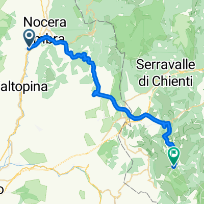
Overview
About this route
La terza tappa dell'impresa quotata 1:25 allo SNAI di Ripatransone
- -:--
- Duration
- 63.1 km
- Distance
- ---
- Ascent
- ---
- Descent
- ---
- Avg. speed
- ---
- Max. altitude

Continue with Bikemap
Use, edit, or download this cycling route
You would like to ride Coast to coast - day 3 or customize it for your own trip? Here is what you can do with this Bikemap route:
Free features
- Save this route as favorite or in collections
- Copy & plan your own version of this route
- Sync your route with Garmin or Wahoo
Premium features
Free trial for 3 days, or one-time payment. More about Bikemap Premium.
- Navigate this route on iOS & Android
- Export a GPX / KML file of this route
- Create your custom printout (try it for free)
- Download this route for offline navigation
Discover more Premium features.
Get Bikemap PremiumFrom our community
Other popular routes starting in Nocera Umbra
 Nocera Scalo 39 - Collattoni
- Distance
- 31.7 km
- Ascent
- 1,074 m
- Descent
- 377 m
- Location
- Nocera Umbra, Umbria, Italy
 Da Via San Rinaldo 9, Nocera Umbra a Via San Giovanni 25, Nocera Umbra
- Distance
- 28.9 km
- Ascent
- 833 m
- Descent
- 831 m
- Location
- Nocera Umbra, Umbria, Italy
 La pazzia di Biribao
- Distance
- 40.6 km
- Ascent
- 1,719 m
- Descent
- 1,660 m
- Location
- Nocera Umbra, Umbria, Italy
 Nocera, Bandita Cilleni, Postignano, Nocera
- Distance
- 27.9 km
- Ascent
- 707 m
- Descent
- 698 m
- Location
- Nocera Umbra, Umbria, Italy
 Da Via Septempedana, Nocera Umbra a Via Amedeo 36, Nocera Umbra
- Distance
- 12.7 km
- Ascent
- 509 m
- Descent
- 486 m
- Location
- Nocera Umbra, Umbria, Italy
 Da Via Martiri della Libertà 64, Nocera Umbra a Via Martiri della Libertà 64, Nocera Umbra
- Distance
- 47.9 km
- Ascent
- 1,563 m
- Descent
- 1,567 m
- Location
- Nocera Umbra, Umbria, Italy
 Gf delle sorgenti 2016
- Distance
- 44.2 km
- Ascent
- 1,135 m
- Descent
- 1,135 m
- Location
- Nocera Umbra, Umbria, Italy
 Monte pennino fioritura
- Distance
- 26.1 km
- Ascent
- 2,076 m
- Descent
- 1,441 m
- Location
- Nocera Umbra, Umbria, Italy
Open it in the app