J. R. Poničana 37 do J. R. Poničana 100
- 16.7 km
- 311 m
- 315 m
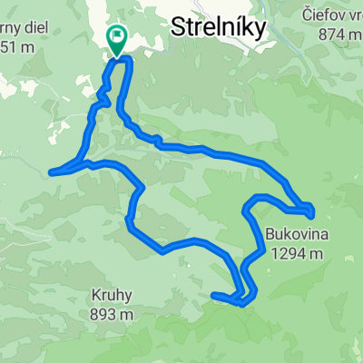
- Hrochoť, Banská Bystrica Region, Slovakia
A cycling route starting in Hrochoť, Banská Bystrica Region, Slovakia.
Overview
The start is in the picturesque village of Povrazník, from where you follow an asphalt road to the saddle under Jaseňový vrch, then slightly downhill under the ridge and through the beautiful Martinova valley along the Zolná stream. Almost at its end, you smoothly transition onto forest roads, which you climb to the Žiarec elevation on the Hrochot ridge of Poľana. From there, it is a short distance to the fantastic nature reserve Pri Bútľavke, or you can enjoy beautiful views into the Hrochotská valley and onto the Jánošík rock. From Žiarec, you then go back a bit and descend along the blue tourist trail through Oravcovo to Veľká Zolná. Slightly below, towards Ponická huta, a forest skid road begins, which you climb up the Granátka hill back to the saddle under Jaseňový vrch and descend via a side path back to Povrazník.
created this 9 years ago
Route quality
Track
18.1 km
(83 %)
Quiet road
3.3 km
(15 %)
Paved
2.6 km
(12 %)
Unpaved
15.9 km
(73 %)
Gravel
7.6 km
(35 %)
Ground
4.6 km
(21 %)
Route highlights

Prírodná rezervácia Pri Bútľavke

Výhľady na Hrochotskú dolinu
Continue with Bikemap
You would like to ride Z Povrazníka na Žiarec a späť or customize it for your own trip? Here is what you can do with this Bikemap route:
Free trial for 3 days, or one-time payment. More about Bikemap Premium.
Discover more Premium features.
Get Bikemap PremiumFrom our community
Open it in the app