
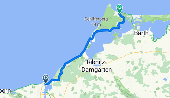
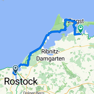
Ostseeradweg 3 Rostock - Prerow
A cycling route starting in Warnemünde, Mecklenburg-Vorpommern, Germany.
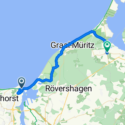
Overview
About this route
Hier Teil 3 des Ostseeradweges.
(cloned from route 2331345)- -:--
- Duration
- 57 km
- Distance
- 58 m
- Ascent
- 59 m
- Descent
- ---
- Avg. speed
- ---
- Max. altitude
Route quality
Waytypes & surfaces along the route
Waytypes
Path
29.6 km
(52 %)
Track
9.1 km
(16 %)
Surfaces
Paved
24.5 km
(43 %)
Unpaved
21.6 km
(38 %)
Asphalt
23.4 km
(41 %)
Gravel
6.8 km
(12 %)
Continue with Bikemap
Use, edit, or download this cycling route
You would like to ride Ostseeradweg 3 Rostock - Prerow or customize it for your own trip? Here is what you can do with this Bikemap route:
Free features
- Save this route as favorite or in collections
- Copy & plan your own version of this route
- Sync your route with Garmin or Wahoo
Premium features
Free trial for 3 days, or one-time payment. More about Bikemap Premium.
- Navigate this route on iOS & Android
- Export a GPX / KML file of this route
- Create your custom printout (try it for free)
- Download this route for offline navigation
Discover more Premium features.
Get Bikemap PremiumFrom our community
Other popular routes starting in Warnemünde
 Von Rostock bis Neustadt in Holstein
- Distance
- 177.5 km
- Ascent
- 864 m
- Descent
- 857 m
- Location
- Warnemünde, Mecklenburg-Vorpommern, Germany
 Schmarl Dorf 17D nach Am Osthafen
- Distance
- 84.1 km
- Ascent
- 171 m
- Descent
- 169 m
- Location
- Warnemünde, Mecklenburg-Vorpommern, Germany
 Am Strom, Rostock nach Kleine Hohe Straße, Wismar
- Distance
- 70 km
- Ascent
- 492 m
- Descent
- 500 m
- Location
- Warnemünde, Mecklenburg-Vorpommern, Germany
 Warnemünde / Graal-Müritz / zurück
- Distance
- 43.3 km
- Ascent
- 53 m
- Descent
- 54 m
- Location
- Warnemünde, Mecklenburg-Vorpommern, Germany
 Parkstraße 46h, Rostock nach Parkstraße 46h, Rostock
- Distance
- 40.4 km
- Ascent
- 171 m
- Descent
- 212 m
- Location
- Warnemünde, Mecklenburg-Vorpommern, Germany
 Mein Schiff 7
- Distance
- 15.4 km
- Ascent
- 55 m
- Descent
- 108 m
- Location
- Warnemünde, Mecklenburg-Vorpommern, Germany
 Von Rostock bis Ribnitz-Damgarten
- Distance
- 32.7 km
- Ascent
- 104 m
- Descent
- 104 m
- Location
- Warnemünde, Mecklenburg-Vorpommern, Germany
 Slow ride in Rostock
- Distance
- 21.8 km
- Ascent
- 52 m
- Descent
- 57 m
- Location
- Warnemünde, Mecklenburg-Vorpommern, Germany
Open it in the app