

Große Heubergrundfahrt
A cycling route starting in Tuttlingen, Baden-Wurttemberg, Germany.
Overview
About this route
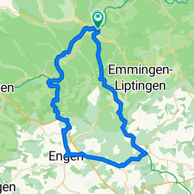
From Tutlingen through the Danube and Bärental valley via Wehingen, Gosheim, down the Heuberg railway path to Spaichingen and back to Tuttlingen.
The route mostly runs on cycle paths. From Tuttlingen to the municipality of Bärental, asphalt. Then alternating gravel and asphalt; from Gosheim gravel again until Spaichingen. After Gosheim, a short dark former railway tunnel where a light is necessary, then a steep descent/ascent under the Aubrücke bridge. According to the bike computer, 470 meters of elevation gain.
- -:--
- Duration
- 63.9 km
- Distance
- 346 m
- Ascent
- 347 m
- Descent
- ---
- Avg. speed
- ---
- Max. altitude

Route quality
Waytypes & surfaces along the route
Waytypes
Track
30.7 km
(48 %)
Quiet road
14.7 km
(23 %)
Surfaces
Paved
46 km
(72 %)
Unpaved
10.2 km
(16 %)
Asphalt
39.6 km
(62 %)
Gravel
8.9 km
(14 %)
Continue with Bikemap
Use, edit, or download this cycling route
You would like to ride Große Heubergrundfahrt or customize it for your own trip? Here is what you can do with this Bikemap route:
Free features
- Save this route as favorite or in collections
- Copy & plan your own version of this route
- Sync your route with Garmin or Wahoo
Premium features
Free trial for 3 days, or one-time payment. More about Bikemap Premium.
- Navigate this route on iOS & Android
- Export a GPX / KML file of this route
- Create your custom printout (try it for free)
- Download this route for offline navigation
Discover more Premium features.
Get Bikemap PremiumFrom our community
Other popular routes starting in Tuttlingen
 4. Etappe_Truttlingen-Riedlingen_19.07.2025
- Distance
- 89.7 km
- Ascent
- 1,292 m
- Descent
- 1,408 m
- Location
- Tuttlingen, Baden-Wurttemberg, Germany
 Große Heubergrundfahrt
- Distance
- 63.9 km
- Ascent
- 346 m
- Descent
- 347 m
- Location
- Tuttlingen, Baden-Wurttemberg, Germany
 EV6 - Day 24
- Distance
- 55.3 km
- Ascent
- 169 m
- Descent
- 244 m
- Location
- Tuttlingen, Baden-Wurttemberg, Germany
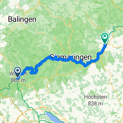
 Emmingen-Liptingen - Sigmaringen
- Distance
- 54.5 km
- Ascent
- 1,095 m
- Descent
- 1,150 m
- Location
- Tuttlingen, Baden-Wurttemberg, Germany
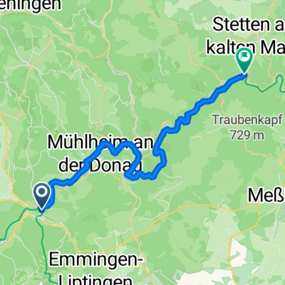 Tuttlingen - Stetten am Kalten Markt
- Distance
- 36.8 km
- Ascent
- 653 m
- Descent
- 684 m
- Location
- Tuttlingen, Baden-Wurttemberg, Germany
 Tuttlingen - Radolfzell - Schaffhausen
- Distance
- 75.5 km
- Ascent
- 1,067 m
- Descent
- 1,321 m
- Location
- Tuttlingen, Baden-Wurttemberg, Germany
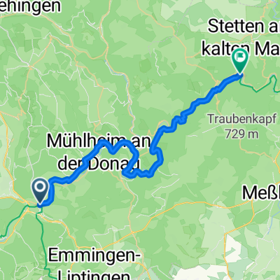 Tuttlingen - Stetten am Kalten Markt
- Distance
- 36.3 km
- Ascent
- 689 m
- Descent
- 709 m
- Location
- Tuttlingen, Baden-Wurttemberg, Germany
 Tuttlingen Tuttlingen DRW SAR EV6
- Distance
- 63.1 km
- Ascent
- 1,000 m
- Descent
- 1,003 m
- Location
- Tuttlingen, Baden-Wurttemberg, Germany
Open it in the app