

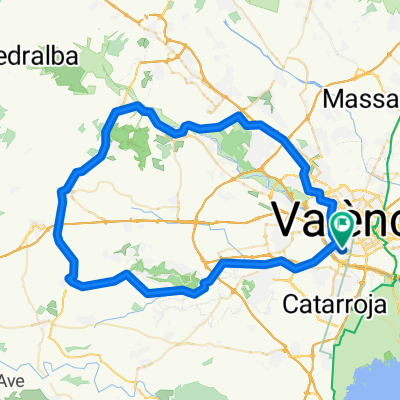
Valencia-Villamarchante-Godelleta-Torrente-Valencia
A cycling route starting in Sedaví, Valencia, Spain.
Overview
About this route
Ruta desde Valencia subiendo Valterna hacia Ribarroja y Villamarchante, pasando por Cheste (almuerzo?) y Godelleta hacia Torrente bordeando Calicanto
- -:--
- Duration
- 86.2 km
- Distance
- 360 m
- Ascent
- 362 m
- Descent
- ---
- Avg. speed
- ---
- Max. altitude
Route quality
Waytypes & surfaces along the route
Waytypes
Quiet road
27.4 km
(32 %)
Busy road
24.8 km
(29 %)
Surfaces
Paved
9.9 km
(11 %)
Unpaved
0.2 km
(<1 %)
Asphalt
8.9 km
(10 %)
Paved (undefined)
0.8 km
(<1 %)
Continue with Bikemap
Use, edit, or download this cycling route
You would like to ride Valencia-Villamarchante-Godelleta-Torrente-Valencia or customize it for your own trip? Here is what you can do with this Bikemap route:
Free features
- Save this route as favorite or in collections
- Copy & plan your own version of this route
- Split it into stages to create a multi-day tour
- Sync your route with Garmin or Wahoo
Premium features
Free trial for 3 days, or one-time payment. More about Bikemap Premium.
- Navigate this route on iOS & Android
- Export a GPX / KML file of this route
- Create your custom printout (try it for free)
- Download this route for offline navigation
Discover more Premium features.
Get Bikemap PremiumFrom our community
Other popular routes starting in Sedaví
 Rondrit Valencia 12 km.
- Distance
- 11.9 km
- Ascent
- 91 m
- Descent
- 92 m
- Location
- Sedaví, Valencia, Spain
 Ruta del colesterol
- Distance
- 5.8 km
- Ascent
- 6 m
- Descent
- 7 m
- Location
- Sedaví, Valencia, Spain
 RUTA FUENTE REAL-CORTA
- Distance
- 88.8 km
- Ascent
- 986 m
- Descent
- 989 m
- Location
- Sedaví, Valencia, Spain
 La Vallesa - Dragon Khan
- Distance
- 50.2 km
- Ascent
- 221 m
- Descent
- 221 m
- Location
- Sedaví, Valencia, Spain
 Pico del Águila-Pto. Almedijar-Pto. Eslida-Pto. Oronet
- Distance
- 170.5 km
- Ascent
- 1,620 m
- Descent
- 1,620 m
- Location
- Sedaví, Valencia, Spain
 Gestalgar por Chiva
- Distance
- 114.6 km
- Ascent
- 753 m
- Descent
- 744 m
- Location
- Sedaví, Valencia, Spain
 Valencia-Villamarchante-Godelleta-Torrente-Valencia
- Distance
- 86.2 km
- Ascent
- 360 m
- Descent
- 362 m
- Location
- Sedaví, Valencia, Spain
 Sedaví- Parador del Saler
- Distance
- 38.3 km
- Ascent
- 29 m
- Descent
- 39 m
- Location
- Sedaví, Valencia, Spain
Open it in the app