

LaCris MTB #1
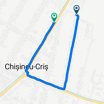
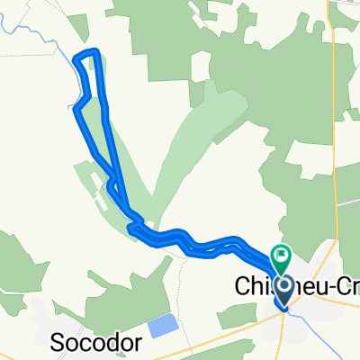
A cycling route starting in Chişineu-Criş, Arad County, Romania.
Overview
About this route
A 4-kilometer stretch of road up to the fishing area, the next intermediate point being the wooden bridge over the Crisul Alb river. This is followed by a loop through the Socodor forest, returning along the Crisul flood defense dike and the river meadow up to the bridge where the only refreshment and general service point will be set up. The road continues towards the town following the Crisul river meadow, then turns onto Teilor Street towards the town center, from there towards Oituz Street and to the start/finish point near the central park.
- -:--
- Duration
- 33 km
- Distance
- 47 m
- Ascent
- 47 m
- Descent
- ---
- Avg. speed
- ---
- Max. altitude

Route highlights
Points of interest along the route
Point of interest after 5.4 km
Pescarie, Balarii..
Point of interest after 8.9 km
Podul de lemn
Continue with Bikemap
Use, edit, or download this cycling route
You would like to ride LaCris MTB #1 or customize it for your own trip? Here is what you can do with this Bikemap route:
Free features
- Save this route as favorite or in collections
- Copy & plan your own version of this route
- Sync your route with Garmin or Wahoo
Premium features
Free trial for 3 days, or one-time payment. More about Bikemap Premium.
- Navigate this route on iOS & Android
- Export a GPX / KML file of this route
- Create your custom printout (try it for free)
- Download this route for offline navigation
Discover more Premium features.
Get Bikemap PremiumFrom our community
Other popular routes starting in Chişineu-Criş
 Cu țoagla pe dig V3
- Distance
- 40.5 km
- Ascent
- 24 m
- Descent
- 25 m
- Location
- Chişineu-Criş, Arad County, Romania
 Cris-Maderat-Casoaia-Highis-Soimos-Cladova-Feredeu-Cris
- Distance
- 162.6 km
- Ascent
- 1,402 m
- Descent
- 1,401 m
- Location
- Chişineu-Criş, Arad County, Romania
 Final
Final- Distance
- 112.8 km
- Ascent
- 521 m
- Descent
- 520 m
- Location
- Chişineu-Criş, Arad County, Romania
 Alternative route
- Distance
- 44 km
- Ascent
- 32 m
- Descent
- 30 m
- Location
- Chişineu-Criş, Arad County, Romania
 Cris-Siria-Highis-Siria-Galsa-Cris
- Distance
- 134.2 km
- Ascent
- 852 m
- Descent
- 850 m
- Location
- Chişineu-Criş, Arad County, Romania
 Strada Înfrățirii do Strada Înfrățirii
- Distance
- 2 km
- Ascent
- 8 m
- Descent
- 52 m
- Location
- Chişineu-Criş, Arad County, Romania
 Concurs Toagla pe Dig
- Distance
- 21.8 km
- Ascent
- 30 m
- Descent
- 30 m
- Location
- Chişineu-Criş, Arad County, Romania
 Cris-Siria-Cetate-Feredeu-Highis-Casoaia-Feredeu-retur
- Distance
- 142.9 km
- Ascent
- 1,070 m
- Descent
- 1,072 m
- Location
- Chişineu-Criş, Arad County, Romania
Open it in the app