

Provence
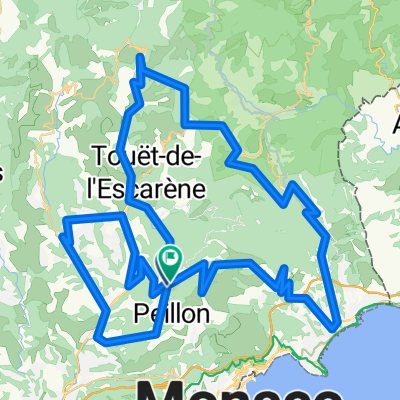
Francia- és Provence Alpok, Cote d'Azur 4. nap
A cycling route starting in Peillon, Provence-Alpes-Côte d'Azur Region, France.
Overview
About this route
Peillon - La Turbie - Monte-Carlo - Èze - Villefranche-sur-Mer - Nice - Saint-Paul-de-Vence - Antibes - Cannes - Lake Saint-Cassien
- -:--
- Duration
- 114.4 km
- Distance
- 1,121 m
- Ascent
- 1,319 m
- Descent
- ---
- Avg. speed
- ---
- Max. altitude

Part of
Provence
8 stages
Route quality
Waytypes & surfaces along the route
Waytypes
Road
19.4 km
(17 %)
Quiet road
17.2 km
(15 %)
Surfaces
Paved
81.2 km
(71 %)
Asphalt
77.8 km
(68 %)
Paved (undefined)
2.3 km
(2 %)
Continue with Bikemap
Use, edit, or download this cycling route
You would like to ride Francia- és Provence Alpok, Cote d'Azur 4. nap or customize it for your own trip? Here is what you can do with this Bikemap route:
Free features
- Save this route as favorite or in collections
- Copy & plan your own version of this route
- Split it into stages to create a multi-day tour
- Sync your route with Garmin or Wahoo
Premium features
Free trial for 3 days, or one-time payment. More about Bikemap Premium.
- Navigate this route on iOS & Android
- Export a GPX / KML file of this route
- Create your custom printout (try it for free)
- Download this route for offline navigation
Discover more Premium features.
Get Bikemap PremiumFrom our community
Other popular routes starting in Peillon
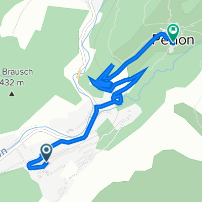 Peillon
- Distance
- 4.4 km
- Ascent
- 231 m
- Descent
- 48 m
- Location
- Peillon, Provence-Alpes-Côte d'Azur Region, France
 TDR2A
TDR2A- Distance
- 56.4 km
- Ascent
- 687 m
- Descent
- 751 m
- Location
- Peillon, Provence-Alpes-Côte d'Azur Region, France
 FRANCIA_112_2662
- Distance
- 112.8 km
- Ascent
- 2,616 m
- Descent
- 2,618 m
- Location
- Peillon, Provence-Alpes-Côte d'Azur Region, France
 Francia- és Provence Alpok, Cote d'Azur 4. nap
- Distance
- 114.4 km
- Ascent
- 1,121 m
- Descent
- 1,319 m
- Location
- Peillon, Provence-Alpes-Côte d'Azur Region, France
 La Grave de Peille 107.3050
- Distance
- 106.8 km
- Ascent
- 2,858 m
- Descent
- 2,859 m
- Location
- Peillon, Provence-Alpes-Côte d'Azur Region, France
 Pays des Paillons
- Distance
- 52.1 km
- Ascent
- 928 m
- Descent
- 1,010 m
- Location
- Peillon, Provence-Alpes-Côte d'Azur Region, France
 TDR1
TDR1- Distance
- 53.3 km
- Ascent
- 1,162 m
- Descent
- 1,168 m
- Location
- Peillon, Provence-Alpes-Côte d'Azur Region, France
 Přes Col du Braus
- Distance
- 59.1 km
- Ascent
- 1,257 m
- Descent
- 1,257 m
- Location
- Peillon, Provence-Alpes-Côte d'Azur Region, France
Open it in the app