

schöne Stauseerunde
A cycling route starting in Cogolin, Provence-Alpes-Côte d'Azur Region, France.
Overview
About this route
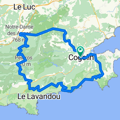
Beautiful ride through the hills of the Côte d'Azur. The route is 50 km long. The starting point was the holiday village 'Village de Campagne' in Gogolin. Particularly interesting was the reservoir that was only half full.
- -:--
- Duration
- 64.3 km
- Distance
- 539 m
- Ascent
- 539 m
- Descent
- ---
- Avg. speed
- ---
- Max. altitude
Continue with Bikemap
Use, edit, or download this cycling route
You would like to ride schöne Stauseerunde or customize it for your own trip? Here is what you can do with this Bikemap route:
Free features
- Save this route as favorite or in collections
- Copy & plan your own version of this route
- Sync your route with Garmin or Wahoo
Premium features
Free trial for 3 days, or one-time payment. More about Bikemap Premium.
- Navigate this route on iOS & Android
- Export a GPX / KML file of this route
- Create your custom printout (try it for free)
- Download this route for offline navigation
Discover more Premium features.
Get Bikemap PremiumFrom our community
Other popular routes starting in Cogolin
 schöne Stauseerunde CLONED FROM ROUTE 83425
- Distance
- 59.9 km
- Ascent
- 525 m
- Descent
- 521 m
- Location
- Cogolin, Provence-Alpes-Côte d'Azur Region, France
 Cogolin-BormesLMimosas via col Canadel
- Distance
- 64.6 km
- Ascent
- 785 m
- Descent
- 786 m
- Location
- Cogolin, Provence-Alpes-Côte d'Azur Region, France
 schöne Stauseerunde
- Distance
- 64.3 km
- Ascent
- 566 m
- Descent
- 566 m
- Location
- Cogolin, Provence-Alpes-Côte d'Azur Region, France
 schöne Stauseerunde CLONED FROM ROUTE 83425
- Distance
- 57.4 km
- Ascent
- 477 m
- Descent
- 507 m
- Location
- Cogolin, Provence-Alpes-Côte d'Azur Region, France
 Provence_Cogolin_sedlo Canadel_Cavaliere
- Distance
- 45.9 km
- Ascent
- 427 m
- Descent
- 442 m
- Location
- Cogolin, Provence-Alpes-Côte d'Azur Region, France
 Cogolin - Collobrieres -La Mole - Rayol-Cavalaire sur mer
- Distance
- 73.7 km
- Ascent
- 1,073 m
- Descent
- 1,052 m
- Location
- Cogolin, Provence-Alpes-Côte d'Azur Region, France
 BABAOU CCC
- Distance
- 84.6 km
- Ascent
- 1,046 m
- Descent
- 1,045 m
- Location
- Cogolin, Provence-Alpes-Côte d'Azur Region, France
 l'Epervier
- Distance
- 127.8 km
- Ascent
- 2,378 m
- Descent
- 2,214 m
- Location
- Cogolin, Provence-Alpes-Côte d'Azur Region, France
Open it in the app