

mont d'or etc
A cycling route starting in Villeurbanne, Auvergne-Rhône-Alpes, France.
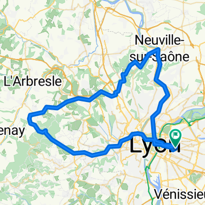
Overview
About this route
not flat as a pancake
- -:--
- Duration
- 73.8 km
- Distance
- 935 m
- Ascent
- 935 m
- Descent
- ---
- Avg. speed
- ---
- Max. altitude
Route quality
Waytypes & surfaces along the route
Waytypes
Road
21.4 km
(29 %)
Quiet road
19.2 km
(26 %)
Surfaces
Paved
45 km
(61 %)
Unpaved
2.2 km
(3 %)
Asphalt
44.3 km
(60 %)
Ground
1.5 km
(2 %)
Continue with Bikemap
Use, edit, or download this cycling route
You would like to ride mont d'or etc or customize it for your own trip? Here is what you can do with this Bikemap route:
Free features
- Save this route as favorite or in collections
- Copy & plan your own version of this route
- Sync your route with Garmin or Wahoo
Premium features
Free trial for 3 days, or one-time payment. More about Bikemap Premium.
- Navigate this route on iOS & Android
- Export a GPX / KML file of this route
- Create your custom printout (try it for free)
- Download this route for offline navigation
Discover more Premium features.
Get Bikemap PremiumFrom our community
Other popular routes starting in Villeurbanne
 Xban Luere
- Distance
- 70.8 km
- Ascent
- 1,000 m
- Descent
- 1,001 m
- Location
- Villeurbanne, Auvergne-Rhône-Alpes, France
 Monts d'or 3
- Distance
- 62.7 km
- Ascent
- 843 m
- Descent
- 843 m
- Location
- Villeurbanne, Auvergne-Rhône-Alpes, France
 Monts d'or 1
- Distance
- 59.7 km
- Ascent
- 1,074 m
- Descent
- 1,073 m
- Location
- Villeurbanne, Auvergne-Rhône-Alpes, France
 Lyon - Montagnieu
- Distance
- 71.8 km
- Ascent
- 306 m
- Descent
- 281 m
- Location
- Villeurbanne, Auvergne-Rhône-Alpes, France
 De Cours Docteur Long 58, Lyon à Cours Docteur Long 58, Lyon
- Distance
- 36.5 km
- Ascent
- 263 m
- Descent
- 263 m
- Location
- Villeurbanne, Auvergne-Rhône-Alpes, France
 mont d'or etc
- Distance
- 73.8 km
- Ascent
- 935 m
- Descent
- 935 m
- Location
- Villeurbanne, Auvergne-Rhône-Alpes, France
 Lyon-Le Mans... et plus !
- Distance
- 807 km
- Ascent
- 1,633 m
- Descent
- 1,637 m
- Location
- Villeurbanne, Auvergne-Rhône-Alpes, France
 Charpennes - Mont Verdun
- Distance
- 39.5 km
- Ascent
- 880 m
- Descent
- 879 m
- Location
- Villeurbanne, Auvergne-Rhône-Alpes, France
Open it in the app