
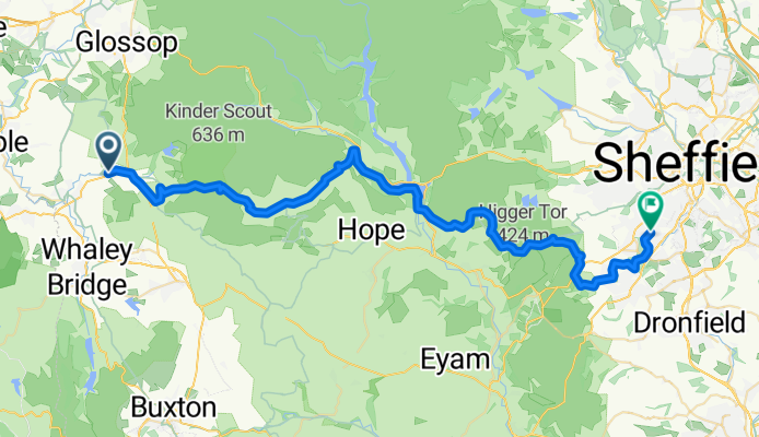
Sett valley trail to Sheffield
A cycling route starting in Hayfield, England, United Kingdom.
Overview
About this route
Sett valley trail to Sheffield including lots of nice descents
- -:--
- Duration
- 46.7 km
- Distance
- 958 m
- Ascent
- 993 m
- Descent
- ---
- Avg. speed
- ---
- Max. altitude
Route quality
Waytypes & surfaces along the route
Waytypes
Cycleway
15.7 km
(33 %)
Road
10.4 km
(22 %)
Surfaces
Paved
14.8 km
(32 %)
Unpaved
23.5 km
(50 %)
Gravel
13 km
(28 %)
Asphalt
12.9 km
(28 %)
Continue with Bikemap
Use, edit, or download this cycling route
You would like to ride Sett valley trail to Sheffield or customize it for your own trip? Here is what you can do with this Bikemap route:
Free features
- Save this route as favorite or in collections
- Copy & plan your own version of this route
- Sync your route with Garmin or Wahoo
Premium features
Free trial for 3 days, or one-time payment. More about Bikemap Premium.
- Navigate this route on iOS & Android
- Export a GPX / KML file of this route
- Create your custom printout (try it for free)
- Download this route for offline navigation
Discover more Premium features.
Get Bikemap PremiumFrom our community
Other popular routes starting in Hayfield
 Oaklands to GG & back
- Distance
- 28.4 km
- Ascent
- 462 m
- Descent
- 458 m
- Location
- Hayfield, England, United Kingdom
 All KIller
- Distance
- 21.9 km
- Ascent
- 803 m
- Descent
- 808 m
- Location
- Hayfield, England, United Kingdom
 Hayfield and Goyt Valley
- Distance
- 30.4 km
- Ascent
- 647 m
- Descent
- 650 m
- Location
- Hayfield, England, United Kingdom
 2 Market St, Hayfield, High Peak to 4 Green Meadows Dr, Stockport
- Distance
- 10.2 km
- Ascent
- 218 m
- Descent
- 286 m
- Location
- Hayfield, England, United Kingdom
 10k Walk Hayfield 01
- Distance
- 10.3 km
- Ascent
- 414 m
- Descent
- 414 m
- Location
- Hayfield, England, United Kingdom
 Hayfield to 'the beast' and back
- Distance
- 37.8 km
- Ascent
- 1,071 m
- Descent
- 1,071 m
- Location
- Hayfield, England, United Kingdom
 Sett valley trail to Sheffield
- Distance
- 46.7 km
- Ascent
- 958 m
- Descent
- 993 m
- Location
- Hayfield, England, United Kingdom
 Hayfield Best descents
- Distance
- 27 km
- Ascent
- 734 m
- Descent
- 734 m
- Location
- Hayfield, England, United Kingdom
Open it in the app