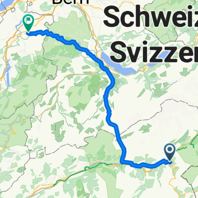
Jour 2 Filet/Andermatt par saint Gothar
A cycling route starting in Naters, Valais, Switzerland.
Overview
About this route
Day 2 Option B 100 km 3000 m+
- -:--
- Duration
- 100.9 km
- Distance
- 2,824 m
- Ascent
- 2,139 m
- Descent
- ---
- Avg. speed
- ---
- Max. altitude
Route quality
Waytypes & surfaces along the route
Waytypes
Track
18.2 km
(18 %)
Road
11.1 km
(11 %)
Surfaces
Paved
66.6 km
(66 %)
Unpaved
10.1 km
(10 %)
Asphalt
62.6 km
(62 %)
Unpaved (undefined)
5 km
(5 %)
Continue with Bikemap
Use, edit, or download this cycling route
You would like to ride Jour 2 Filet/Andermatt par saint Gothar or customize it for your own trip? Here is what you can do with this Bikemap route:
Free features
- Save this route as favorite or in collections
- Copy & plan your own version of this route
- Split it into stages to create a multi-day tour
- Sync your route with Garmin or Wahoo
Premium features
Free trial for 3 days, or one-time payment. More about Bikemap Premium.
- Navigate this route on iOS & Android
- Export a GPX / KML file of this route
- Create your custom printout (try it for free)
- Download this route for offline navigation
Discover more Premium features.
Get Bikemap PremiumFrom our community
Other popular routes starting in Naters
- Nouveau parcours
- Distance
- 2.8 km
- Ascent
- 185 m
- Descent
- 32 m
- Location
- Naters, Valais, Switzerland
- über den Saflisch-Pass
- Distance
- 54.3 km
- Ascent
- 2,148 m
- Descent
- 2,147 m
- Location
- Naters, Valais, Switzerland
- Jour 2 Filet/Andermatt par saint Gothar
- Distance
- 100.9 km
- Ascent
- 2,824 m
- Descent
- 2,139 m
- Location
- Naters, Valais, Switzerland
- Riederalp
- Distance
- 16.3 km
- Ascent
- 1,256 m
- Descent
- 127 m
- Location
- Naters, Valais, Switzerland
- Alpenrundtour 2010
- Distance
- 733.9 km
- Ascent
- 9,564 m
- Descent
- 9,627 m
- Location
- Naters, Valais, Switzerland
- Naters -Belalp-nessel-birgisch
- Distance
- 27.7 km
- Ascent
- 1,402 m
- Descent
- 1,401 m
- Location
- Naters, Valais, Switzerland
- Day 2. Crans Montana - Andermatt
- Distance
- 91.5 km
- Ascent
- 2,314 m
- Descent
- 1,559 m
- Location
- Naters, Valais, Switzerland
- Mörel-Tunetschalp-Mörel
- Distance
- 18.1 km
- Ascent
- 855 m
- Descent
- 857 m
- Location
- Naters, Valais, Switzerland
Open it in the app