

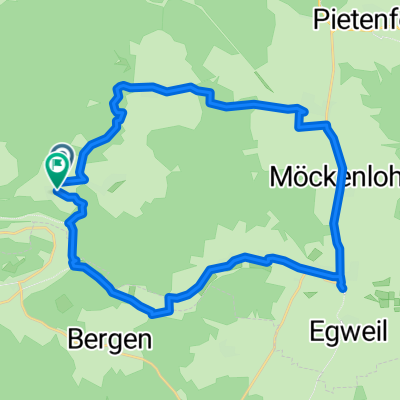
Adelschlag Parkhaus Weinsteige links
A cycling route starting in Adelschlag, Bavaria, Germany.
Overview
About this route
hilly
- -:--
- Duration
- 15.6 km
- Distance
- 208 m
- Ascent
- 206 m
- Descent
- ---
- Avg. speed
- ---
- Max. altitude
Route quality
Waytypes & surfaces along the route
Waytypes
Path
6.4 km
(41 %)
Track
5.9 km
(38 %)
Surfaces
Paved
7 km
(45 %)
Unpaved
7.2 km
(46 %)
Asphalt
7 km
(45 %)
Gravel
5.3 km
(34 %)
Continue with Bikemap
Use, edit, or download this cycling route
You would like to ride Adelschlag Parkhaus Weinsteige links or customize it for your own trip? Here is what you can do with this Bikemap route:
Free features
- Save this route as favorite or in collections
- Copy & plan your own version of this route
- Sync your route with Garmin or Wahoo
Premium features
Free trial for 3 days, or one-time payment. More about Bikemap Premium.
- Navigate this route on iOS & Android
- Export a GPX / KML file of this route
- Create your custom printout (try it for free)
- Download this route for offline navigation
Discover more Premium features.
Get Bikemap PremiumFrom our community
Other popular routes starting in Adelschlag
 St.-Josef-Straße nach St.-Josef-Straße
- Distance
- 29.5 km
- Ascent
- 300 m
- Descent
- 342 m
- Location
- Adelschlag, Bavaria, Germany
 Von Adelschlag bis Rostock
- Distance
- 904.7 km
- Ascent
- 5,469 m
- Descent
- 5,897 m
- Location
- Adelschlag, Bavaria, Germany
 Aicha-Tagmersheim-Dollnstein-Aicha
- Distance
- 39.4 km
- Ascent
- 633 m
- Descent
- 643 m
- Location
- Adelschlag, Bavaria, Germany
 BY-Rundtour Wellheim
- Distance
- 99 km
- Ascent
- 1,056 m
- Descent
- 1,057 m
- Location
- Adelschlag, Bavaria, Germany
 Adelschlag - Schwabach
- Distance
- 78.3 km
- Ascent
- 858 m
- Descent
- 958 m
- Location
- Adelschlag, Bavaria, Germany
 Kinding Nennslingen Wasserzell
- Distance
- 111.4 km
- Ascent
- 400 m
- Descent
- 400 m
- Location
- Adelschlag, Bavaria, Germany
 Hard-Adelschlag-Hard
- Distance
- 27.9 km
- Ascent
- 425 m
- Descent
- 427 m
- Location
- Adelschlag, Bavaria, Germany
 St.-Josef-Straße nach St.-Josef-Straße
- Distance
- 28 km
- Ascent
- 401 m
- Descent
- 447 m
- Location
- Adelschlag, Bavaria, Germany
Open it in the app