[ITA] #1
A cycling route starting in Povo, Trentino-Alto Adige, Italy.
Overview
About this route
<p>
ITA #1</p>
<p>
(cloned from route 2711720)</p>
Translated, show original (Italian)- -:--
- Duration
- 45 km
- Distance
- 674 m
- Ascent
- 675 m
- Descent
- ---
- Avg. speed
- ---
- Max. altitude
Route quality
Waytypes & surfaces along the route
Waytypes
Road
10.4 km
(23 %)
Quiet road
9.9 km
(22 %)
Surfaces
Paved
41.4 km
(92 %)
Asphalt
41.4 km
(92 %)
Undefined
3.6 km
(8 %)
Continue with Bikemap
Use, edit, or download this cycling route
You would like to ride [ITA] #1 or customize it for your own trip? Here is what you can do with this Bikemap route:
Free features
- Save this route as favorite or in collections
- Copy & plan your own version of this route
- Sync your route with Garmin or Wahoo
Premium features
Free trial for 3 days, or one-time payment. More about Bikemap Premium.
- Navigate this route on iOS & Android
- Export a GPX / KML file of this route
- Create your custom printout (try it for free)
- Download this route for offline navigation
Discover more Premium features.
Get Bikemap PremiumFrom our community
Other popular routes starting in Povo
- Trient - Caldonazzosee - Trient
- Distance
- 42.3 km
- Ascent
- 393 m
- Descent
- 401 m
- Location
- Povo, Trentino-Alto Adige, Italy
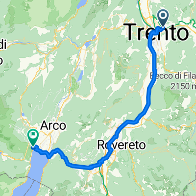
- Trient - Riva del Garda
- Distance
- 52.1 km
- Ascent
- 134 m
- Descent
- 446 m
- Location
- Povo, Trentino-Alto Adige, Italy
- San't Agnese
- Distance
- 39.4 km
- Ascent
- 1,032 m
- Descent
- 1,033 m
- Location
- Povo, Trentino-Alto Adige, Italy
- Panarotta
- Distance
- 59 km
- Ascent
- 1,541 m
- Descent
- 1,541 m
- Location
- Povo, Trentino-Alto Adige, Italy
- Messiano - Lago di Garda - Messiano
- Distance
- 95.1 km
- Ascent
- 816 m
- Descent
- 817 m
- Location
- Povo, Trentino-Alto Adige, Italy
- Lago di Levico
- Distance
- 46.9 km
- Ascent
- 770 m
- Descent
- 771 m
- Location
- Povo, Trentino-Alto Adige, Italy
- villazzano 2 laghi Vigolo Vattaro
- Distance
- 50.6 km
- Ascent
- 706 m
- Descent
- 704 m
- Location
- Povo, Trentino-Alto Adige, Italy
- Valsorda-Tenna
- Distance
- 48 km
- Ascent
- 1,048 m
- Descent
- 1,049 m
- Location
- Povo, Trentino-Alto Adige, Italy
Open it in the app