

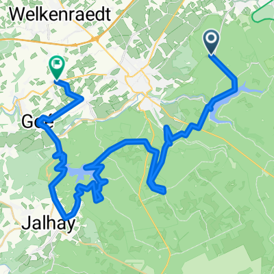
Eynatten nach Aachen 3/2016
A cycling route starting in Raeren, Wallonia, Belgium.
Overview
About this route
Flat route along the Vennradweg to Aachen city center (cloned from route 3301194) (cloned from route 3301195)
- -:--
- Duration
- 22.4 km
- Distance
- 84 m
- Ascent
- 174 m
- Descent
- ---
- Avg. speed
- ---
- Max. altitude

Route quality
Waytypes & surfaces along the route
Waytypes
Path
10.5 km
(47 %)
Quiet road
9.9 km
(44 %)
Surfaces
Paved
18.8 km
(84 %)
Unpaved
0.2 km
(1 %)
Asphalt
18.6 km
(83 %)
Concrete
0.2 km
(1 %)
Continue with Bikemap
Use, edit, or download this cycling route
You would like to ride Eynatten nach Aachen 3/2016 or customize it for your own trip? Here is what you can do with this Bikemap route:
Free features
- Save this route as favorite or in collections
- Copy & plan your own version of this route
- Sync your route with Garmin or Wahoo
Premium features
Free trial for 3 days, or one-time payment. More about Bikemap Premium.
- Navigate this route on iOS & Android
- Export a GPX / KML file of this route
- Create your custom printout (try it for free)
- Download this route for offline navigation
Discover more Premium features.
Get Bikemap PremiumFrom our community
Other popular routes starting in Raeren
 Langenbend nach Monschauer Straße
- Distance
- 11.3 km
- Ascent
- 41 m
- Descent
- 167 m
- Location
- Raeren, Wallonia, Belgium
 Eynatten nach Aachen 3/2016
- Distance
- 22.4 km
- Ascent
- 84 m
- Descent
- 174 m
- Location
- Raeren, Wallonia, Belgium
 Raeren Maastricht
- Distance
- 51.2 km
- Ascent
- 234 m
- Descent
- 478 m
- Location
- Raeren, Wallonia, Belgium
 Raeren-PlopsaCoo 2019
- Distance
- 77.9 km
- Ascent
- 395 m
- Descent
- 498 m
- Location
- Raeren, Wallonia, Belgium
 Aa06-BurgRaeren-Monschau-52km
- Distance
- 52.1 km
- Ascent
- 474 m
- Descent
- 474 m
- Location
- Raeren, Wallonia, Belgium
 Langenbend nach Zieglerstraße
- Distance
- 17.4 km
- Ascent
- 7 m
- Descent
- 184 m
- Location
- Raeren, Wallonia, Belgium
 Talsperre-Gileppe
- Distance
- 43.1 km
- Ascent
- 601 m
- Descent
- 703 m
- Location
- Raeren, Wallonia, Belgium
 hoge venen wandeling
- Distance
- 9.5 km
- Ascent
- 58 m
- Descent
- 54 m
- Location
- Raeren, Wallonia, Belgium
Open it in the app