

Rund um Fugau
A cycling route starting in Steinigtwolmsdorf, Saxony, Germany.
Overview
About this route
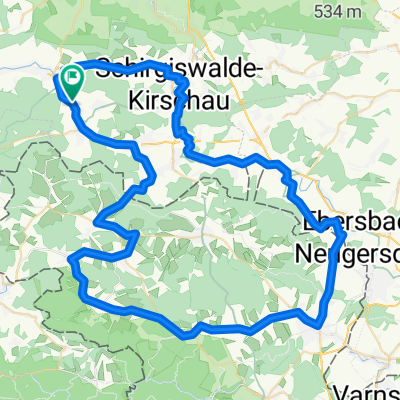
Hügelige Tour durchs Oberlausitzer Bergland, zum größten Teil dem Verlauf der Spree folgend.
Los gehts in Ringenhain. Zunächst leichtes Einrollen über Neukirch und Wilthen nach Kirschau. Von dort über mehrere kleinere Stiche zum Sohlander Stausee. Weiter spreeaufwärts über Taubenheim nach Neusalza. Das Spreetal verlassen nach Schönberg und weiter über den Höhenzug wieder ins Tal nach Ebersbach. Parallel zur tschechischen Grenze nach Neugersdorf und dort über den Grenzübergang nach Tschechien. Von Jirikov (Georgswalde) über einen steilen Anstieg und folgender langer Abfahrt nach Sluknov (Schluckenau). Zurück über die Grenze nach Sohland und über Wehrsdorf und den Steinberg zum Ausgangspunkt in Ringenhain.
- -:--
- Duration
- 66.2 km
- Distance
- 448 m
- Ascent
- 448 m
- Descent
- ---
- Avg. speed
- ---
- Max. altitude

Continue with Bikemap
Use, edit, or download this cycling route
You would like to ride Rund um Fugau or customize it for your own trip? Here is what you can do with this Bikemap route:
Free features
- Save this route as favorite or in collections
- Copy & plan your own version of this route
- Sync your route with Garmin or Wahoo
Premium features
Free trial for 3 days, or one-time payment. More about Bikemap Premium.
- Navigate this route on iOS & Android
- Export a GPX / KML file of this route
- Create your custom printout (try it for free)
- Download this route for offline navigation
Discover more Premium features.
Get Bikemap PremiumFrom our community
Other popular routes starting in Steinigtwolmsdorf
 Oberlausitzer Runde
- Distance
- 58.8 km
- Ascent
- 433 m
- Descent
- 445 m
- Location
- Steinigtwolmsdorf, Saxony, Germany
 Wesenitz
- Distance
- 57 km
- Ascent
- 231 m
- Descent
- 500 m
- Location
- Steinigtwolmsdorf, Saxony, Germany
 Ringenhain-Hochkirch-Ringenhain
- Distance
- 57.6 km
- Ascent
- 712 m
- Descent
- 735 m
- Location
- Steinigtwolmsdorf, Saxony, Germany
 Rund um die Mandau-Quelle
- Distance
- 78.2 km
- Ascent
- 645 m
- Descent
- 629 m
- Location
- Steinigtwolmsdorf, Saxony, Germany
 cesta na jih
- Distance
- 391 km
- Ascent
- 1,580 m
- Descent
- 1,291 m
- Location
- Steinigtwolmsdorf, Saxony, Germany
 Rund um Fugau
- Distance
- 66.2 km
- Ascent
- 448 m
- Descent
- 448 m
- Location
- Steinigtwolmsdorf, Saxony, Germany
 Rund um den Kottmar
- Distance
- 74 km
- Ascent
- 708 m
- Descent
- 758 m
- Location
- Steinigtwolmsdorf, Saxony, Germany
 Rund um den Unger
- Distance
- 86.7 km
- Ascent
- 875 m
- Descent
- 862 m
- Location
- Steinigtwolmsdorf, Saxony, Germany
Open it in the app