

Trailtour im oberen Filstal
A cycling route starting in Aichelberg, Baden-Wurttemberg, Germany.
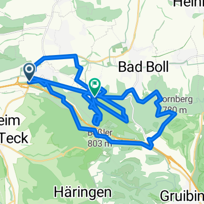
Overview
About this route
TEASI Track
- -:--
- Duration
- 47.7 km
- Distance
- 872 m
- Ascent
- 872 m
- Descent
- ---
- Avg. speed
- ---
- Max. altitude
Route highlights
Points of interest along the route
Point of interest after 1 km
Links1
Point of interest after 3.9 km
Kreuzung2
Point of interest after 6.7 km
Kreuzung3
Point of interest after 14.7 km
Links2
Point of interest after 15.1 km
ACHTUNG
Point of interest after 17.4 km
Links3
Point of interest after 18.4 km
Links4
Point of interest after 24.8 km
Mitte
Point of interest after 42.3 km
Deutsches Haus
Point of interest after 46.8 km
Kreuzung1
Continue with Bikemap
Use, edit, or download this cycling route
You would like to ride Trailtour im oberen Filstal or customize it for your own trip? Here is what you can do with this Bikemap route:
Free features
- Save this route as favorite or in collections
- Copy & plan your own version of this route
- Sync your route with Garmin or Wahoo
Premium features
Free trial for 3 days, or one-time payment. More about Bikemap Premium.
- Navigate this route on iOS & Android
- Export a GPX / KML file of this route
- Create your custom printout (try it for free)
- Download this route for offline navigation
Discover more Premium features.
Get Bikemap PremiumFrom our community
Other popular routes starting in Aichelberg
 Route01
- Distance
- 41.5 km
- Ascent
- 1,099 m
- Descent
- 746 m
- Location
- Aichelberg, Baden-Wurttemberg, Germany
 Bad Boll Apfelblüte
- Distance
- 9.2 km
- Ascent
- 346 m
- Descent
- 310 m
- Location
- Aichelberg, Baden-Wurttemberg, Germany
 20180314_Albtraufradteam
- Distance
- 30.2 km
- Ascent
- 731 m
- Descent
- 813 m
- Location
- Aichelberg, Baden-Wurttemberg, Germany
 Boller Straße 5, Aichelberg nach Boller Straße 3, Aichelberg
- Distance
- 9.7 km
- Ascent
- 116 m
- Descent
- 120 m
- Location
- Aichelberg, Baden-Wurttemberg, Germany
 ST Aichwald
- Distance
- 28.2 km
- Ascent
- 825 m
- Descent
- 787 m
- Location
- Aichelberg, Baden-Wurttemberg, Germany
 Aichelberg-Ellwangen
- Distance
- 92.4 km
- Ascent
- 853 m
- Descent
- 825 m
- Location
- Aichelberg, Baden-Wurttemberg, Germany
 Trailtour im oberen Filstal
- Distance
- 47.7 km
- Ascent
- 872 m
- Descent
- 872 m
- Location
- Aichelberg, Baden-Wurttemberg, Germany
 KA Tag 3
- Distance
- 127.2 km
- Ascent
- 1,106 m
- Descent
- 1,377 m
- Location
- Aichelberg, Baden-Wurttemberg, Germany
Open it in the app