

aaa-yoyogi
A cycling route starting in Naka, Ibaraki, Japan.
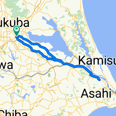
Overview
About this route
tsukuba-tsukubamirai-toride-moriya-toride-kashiwa-nagareyama-matsudo-kasushika-sumida-taito-chiyoda-shinjuku-minato-shinjuku-shibuya
- -:--
- Duration
- 67.1 km
- Distance
- 122 m
- Ascent
- 114 m
- Descent
- ---
- Avg. speed
- ---
- Max. altitude
Continue with Bikemap
Use, edit, or download this cycling route
You would like to ride aaa-yoyogi or customize it for your own trip? Here is what you can do with this Bikemap route:
Free features
- Save this route as favorite or in collections
- Copy & plan your own version of this route
- Sync your route with Garmin or Wahoo
Premium features
Free trial for 3 days, or one-time payment. More about Bikemap Premium.
- Navigate this route on iOS & Android
- Export a GPX / KML file of this route
- Create your custom printout (try it for free)
- Download this route for offline navigation
Discover more Premium features.
Get Bikemap PremiumFrom our community
Other popular routes starting in Naka
 Tsukuba-Hitachinaka
- Distance
- 65.9 km
- Ascent
- 175 m
- Descent
- 175 m
- Location
- Naka, Ibaraki, Japan
 【茨城県】サイクリングで行く土浦の桜スポット5選&サイクリング魅力ポイント
- Distance
- 31.6 km
- Ascent
- 81 m
- Descent
- 80 m
- Location
- Naka, Ibaraki, Japan
 kasumigaura
- Distance
- 124.9 km
- Ascent
- 44 m
- Descent
- 48 m
- Location
- Naka, Ibaraki, Japan
 aaa-yoyogi
- Distance
- 67.1 km
- Ascent
- 122 m
- Descent
- 114 m
- Location
- Naka, Ibaraki, Japan
 20160327
- Distance
- 119.5 km
- Ascent
- 118 m
- Descent
- 117 m
- Location
- Naka, Ibaraki, Japan
 Tsuchiura-Rinrin
- Distance
- 37.8 km
- Ascent
- 292 m
- Descent
- 290 m
- Location
- Naka, Ibaraki, Japan
 20160328
- Distance
- 45.2 km
- Ascent
- 186 m
- Descent
- 188 m
- Location
- Naka, Ibaraki, Japan
 Tsukuba - Tsuchiura
- Distance
- 43.2 km
- Ascent
- 872 m
- Descent
- 870 m
- Location
- Naka, Ibaraki, Japan
Open it in the app