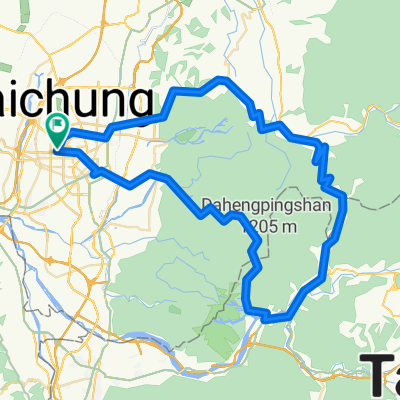
Tainan
A cycling route starting in Taichung, Taiwan, Taiwan.
Overview
About this route
flat
- -:--
- Duration
- 184.4 km
- Distance
- 57 m
- Ascent
- 134 m
- Descent
- ---
- Avg. speed
- ---
- Max. altitude
Route quality
Waytypes & surfaces along the route
Waytypes
Road
29.5 km
(16 %)
Quiet road
29.5 km
(16 %)
Surfaces
Paved
53.5 km
(29 %)
Asphalt
53.5 km
(29 %)
Undefined
130.9 km
(71 %)
Continue with Bikemap
Use, edit, or download this cycling route
You would like to ride Tainan or customize it for your own trip? Here is what you can do with this Bikemap route:
Free features
- Save this route as favorite or in collections
- Copy & plan your own version of this route
- Split it into stages to create a multi-day tour
- Sync your route with Garmin or Wahoo
Premium features
Free trial for 3 days, or one-time payment. More about Bikemap Premium.
- Navigate this route on iOS & Android
- Export a GPX / KML file of this route
- Create your custom printout (try it for free)
- Download this route for offline navigation
Discover more Premium features.
Get Bikemap PremiumFrom our community
Other popular routes starting in Taichung
- 環島路線-海線
- Distance
- 1,073 km
- Ascent
- 1,095 m
- Descent
- 1,095 m
- Location
- Taichung, Taiwan, Taiwan
- 傳說中的136
- Distance
- 19.2 km
- Ascent
- 997 m
- Descent
- 961 m
- Location
- Taichung, Taiwan, Taiwan
- 一日一望高 可以遠離醫生
- Distance
- 36 km
- Ascent
- 334 m
- Descent
- 311 m
- Location
- Taichung, Taiwan, Taiwan
- 台中-日月潭
- Distance
- 157.8 km
- Ascent
- 1,048 m
- Descent
- 1,048 m
- Location
- Taichung, Taiwan, Taiwan
- 太平_老鼠崎
- Distance
- 8.4 km
- Ascent
- 473 m
- Descent
- 457 m
- Location
- Taichung, Taiwan, Taiwan
- 台中-日月潭
- Distance
- 72.4 km
- Ascent
- 1,089 m
- Descent
- 559 m
- Location
- Taichung, Taiwan, Taiwan
- 136
- Distance
- 19.3 km
- Ascent
- 754 m
- Descent
- 297 m
- Location
- Taichung, Taiwan, Taiwan
- 日月潭 平易近人 路線
- Distance
- 149.1 km
- Ascent
- 1,064 m
- Descent
- 1,062 m
- Location
- Taichung, Taiwan, Taiwan
Open it in the app