

Arcos-Buitre-Prado-Tayuelo-Sierra-Arcos
A cycling route starting in Arcos de las Salinas, Aragon, Spain.
Overview
About this route
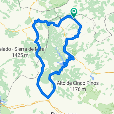
We depart from Arcos towards the source of the river Arcos, then we will climb to the peak of Buitre via a new track not shown on the maps. From there, we will continue climbing towards the collado del Prado, making waves. Optionally, from the collado del Prado, we can approach the pico de Javalambre, which is 3 km away, adding another 6 km to the route. From the collado del Prado, we will descend to the corrales del Tayuelo, following the marks of the "Matahombres", and once at the corrales, we will ascend to the collado del Tayuelo. We will continue descending to the corrales de la Sierra, where we will turn left and take a track that will take us back to the track that comes from Arcos, where we will return to the starting point.
- -:--
- Duration
- 36.7 km
- Distance
- 1,339 m
- Ascent
- 1,339 m
- Descent
- ---
- Avg. speed
- ---
- Max. altitude
Continue with Bikemap
Use, edit, or download this cycling route
You would like to ride Arcos-Buitre-Prado-Tayuelo-Sierra-Arcos or customize it for your own trip? Here is what you can do with this Bikemap route:
Free features
- Save this route as favorite or in collections
- Copy & plan your own version of this route
- Sync your route with Garmin or Wahoo
Premium features
Free trial for 3 days, or one-time payment. More about Bikemap Premium.
- Navigate this route on iOS & Android
- Export a GPX / KML file of this route
- Create your custom printout (try it for free)
- Download this route for offline navigation
Discover more Premium features.
Get Bikemap PremiumFrom our community
Other popular routes starting in Arcos de las Salinas
 Arcos-Buitre-Prado-Tayuelo-Sierra-Arcos
- Distance
- 36.7 km
- Ascent
- 1,339 m
- Descent
- 1,339 m
- Location
- Arcos de las Salinas, Aragon, Spain
 Santa Catalina - Pico del Buitre
- Distance
- 51.4 km
- Ascent
- 1,561 m
- Descent
- 1,561 m
- Location
- Arcos de las Salinas, Aragon, Spain
 javalambre a pie
- Distance
- 39 km
- Ascent
- 1,333 m
- Descent
- 1,333 m
- Location
- Arcos de las Salinas, Aragon, Spain
 Ruta a Arcos de las Salinas
- Distance
- 9.9 km
- Ascent
- 666 m
- Descent
- 27 m
- Location
- Arcos de las Salinas, Aragon, Spain
 El Collado - Pico del Remedio
- Distance
- 141 km
- Ascent
- 1,969 m
- Descent
- 1,969 m
- Location
- Arcos de las Salinas, Aragon, Spain
 El Collado - Santa Cruz - Sinacas - Utiel - Benajéber - Tuéjar - Alpuente - El Collado
- Distance
- 163.5 km
- Ascent
- 1,767 m
- Descent
- 1,774 m
- Location
- Arcos de las Salinas, Aragon, Spain
 ARCOS DE LAS SALINAS,JAVALAMBRE
- Distance
- 43.8 km
- Ascent
- 1,058 m
- Descent
- 1,076 m
- Location
- Arcos de las Salinas, Aragon, Spain
 Etapa 2 MV Road
- Distance
- 89.8 km
- Ascent
- 1,794 m
- Descent
- 1,726 m
- Location
- Arcos de las Salinas, Aragon, Spain
Open it in the app