

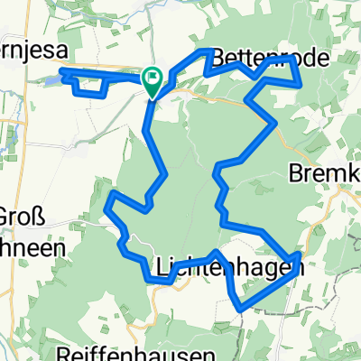
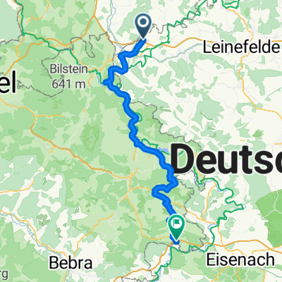
von Nohra (bei Nordhausen) nach Ludolfshausen
A cycling route starting in Rohrberg, Thuringia, Germany.
Overview
About this route
on the way to Ludolfshausen
- -:--
- Duration
- 61.2 km
- Distance
- 256 m
- Ascent
- 339 m
- Descent
- ---
- Avg. speed
- ---
- Max. altitude
Route quality
Waytypes & surfaces along the route
Waytypes
Track
16.5 km
(27 %)
Cycleway
11.6 km
(19 %)
Surfaces
Paved
42.9 km
(70 %)
Unpaved
3.7 km
(6 %)
Asphalt
39.2 km
(64 %)
Ground
2.4 km
(4 %)
Continue with Bikemap
Use, edit, or download this cycling route
You would like to ride von Nohra (bei Nordhausen) nach Ludolfshausen or customize it for your own trip? Here is what you can do with this Bikemap route:
Free features
- Save this route as favorite or in collections
- Copy & plan your own version of this route
- Sync your route with Garmin or Wahoo
Premium features
Free trial for 3 days, or one-time payment. More about Bikemap Premium.
- Navigate this route on iOS & Android
- Export a GPX / KML file of this route
- Create your custom printout (try it for free)
- Download this route for offline navigation
Discover more Premium features.
Get Bikemap PremiumFrom our community
Other popular routes starting in Rohrberg
 34 km MTB Easy Tour
- Distance
- 33.6 km
- Ascent
- 547 m
- Descent
- 547 m
- Location
- Rohrberg, Thuringia, Germany
 von Nohra (bei Nordhausen) nach Ludolfshausen
- Distance
- 61.2 km
- Ascent
- 256 m
- Descent
- 339 m
- Location
- Rohrberg, Thuringia, Germany
 Rohrberg - Herleshausen
- Distance
- 73.6 km
- Ascent
- 160 m
- Descent
- 152 m
- Location
- Rohrberg, Thuringia, Germany
 Über den Roten Berg
- Distance
- 86.1 km
- Ascent
- 625 m
- Descent
- 625 m
- Location
- Rohrberg, Thuringia, Germany
 40 km MTB Easy Tour
- Distance
- 40.4 km
- Ascent
- 676 m
- Descent
- 676 m
- Location
- Rohrberg, Thuringia, Germany
 30km MTB Rohrberg
- Distance
- 31.1 km
- Ascent
- 536 m
- Descent
- 513 m
- Location
- Rohrberg, Thuringia, Germany
 Auf und Ab Reinhausen -- Eichsfeld
- Distance
- 86.4 km
- Ascent
- 800 m
- Descent
- 797 m
- Location
- Rohrberg, Thuringia, Germany
 Rosental, Gleichen nach Hans-Böckler-Straße, Göttingen
- Distance
- 16.2 km
- Ascent
- 74 m
- Descent
- 92 m
- Location
- Rohrberg, Thuringia, Germany
Open it in the app