

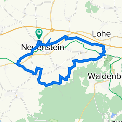
Neuenstein-Hirschhorn
A cycling route starting in Neuenstein, Baden-Wurttemberg, Germany.
Overview
About this route
Neuenstei-Ohrnberg-Kochertalradweg-Jagstfeld-Neckartalradweg-Hirschhorn. by train via Heilbronn back to Neuenstein
- -:--
- Duration
- 94.6 km
- Distance
- 304 m
- Ascent
- 463 m
- Descent
- ---
- Avg. speed
- ---
- Max. altitude

Route quality
Waytypes & surfaces along the route
Waytypes
Quiet road
30.3 km
(32 %)
Track
24.6 km
(26 %)
Surfaces
Paved
77.6 km
(82 %)
Unpaved
7.6 km
(8 %)
Asphalt
75.7 km
(80 %)
Gravel
6.6 km
(7 %)
Continue with Bikemap
Use, edit, or download this cycling route
You would like to ride Neuenstein-Hirschhorn or customize it for your own trip? Here is what you can do with this Bikemap route:
Free features
- Save this route as favorite or in collections
- Copy & plan your own version of this route
- Split it into stages to create a multi-day tour
- Sync your route with Garmin or Wahoo
Premium features
Free trial for 3 days, or one-time payment. More about Bikemap Premium.
- Navigate this route on iOS & Android
- Export a GPX / KML file of this route
- Create your custom printout (try it for free)
- Download this route for offline navigation
Discover more Premium features.
Get Bikemap PremiumFrom our community
Other popular routes starting in Neuenstein
 Neuenstein-Kochertalroute
- Distance
- 70 km
- Ascent
- 377 m
- Descent
- 377 m
- Location
- Neuenstein, Baden-Wurttemberg, Germany
 Zum Breitenauer See
- Distance
- 22.2 km
- Ascent
- 176 m
- Descent
- 247 m
- Location
- Neuenstein, Baden-Wurttemberg, Germany
 Einkauf
- Distance
- 6.3 km
- Ascent
- 62 m
- Descent
- 65 m
- Location
- Neuenstein, Baden-Wurttemberg, Germany
 Neuenstein-Hirschhorn
- Distance
- 94.6 km
- Ascent
- 304 m
- Descent
- 463 m
- Location
- Neuenstein, Baden-Wurttemberg, Germany
 Um Neuenstein
- Distance
- 18.1 km
- Ascent
- 163 m
- Descent
- 165 m
- Location
- Neuenstein, Baden-Wurttemberg, Germany
 neuenstein-schuppach-Waldenburger berge
- Distance
- 39.1 km
- Ascent
- 355 m
- Descent
- 356 m
- Location
- Neuenstein, Baden-Wurttemberg, Germany
 Um Neuenstein
- Distance
- 41.6 km
- Ascent
- 284 m
- Descent
- 283 m
- Location
- Neuenstein, Baden-Wurttemberg, Germany
 Kocher-Ohrn-Eppach Radweg
- Distance
- 75 km
- Ascent
- 310 m
- Descent
- 306 m
- Location
- Neuenstein, Baden-Wurttemberg, Germany
Open it in the app