

Góra św. Anny
A cycling route starting in Żernica, Silesian Voivodeship, Poland.
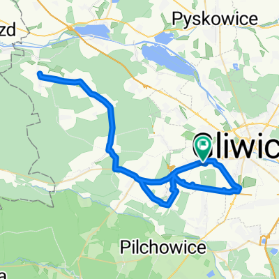
Overview
About this route
Idealna trasa na szosowy długi trening z 1 mocnym akcentem.
- -:--
- Duration
- 126.2 km
- Distance
- 449 m
- Ascent
- 453 m
- Descent
- ---
- Avg. speed
- ---
- Max. altitude
Route quality
Waytypes & surfaces along the route
Waytypes
Road
42.9 km
(34 %)
Quiet road
15.1 km
(12 %)
Surfaces
Paved
92.1 km
(73 %)
Unpaved
2.5 km
(2 %)
Asphalt
92.1 km
(73 %)
Unpaved (undefined)
1.3 km
(1 %)
Continue with Bikemap
Use, edit, or download this cycling route
You would like to ride Góra św. Anny or customize it for your own trip? Here is what you can do with this Bikemap route:
Free features
- Save this route as favorite or in collections
- Copy & plan your own version of this route
- Split it into stages to create a multi-day tour
- Sync your route with Garmin or Wahoo
Premium features
Free trial for 3 days, or one-time payment. More about Bikemap Premium.
- Navigate this route on iOS & Android
- Export a GPX / KML file of this route
- Create your custom printout (try it for free)
- Download this route for offline navigation
Discover more Premium features.
Get Bikemap PremiumFrom our community
Other popular routes starting in Żernica
 Sierpniowy
- Distance
- 445.1 km
- Ascent
- 1,551 m
- Descent
- 1,574 m
- Location
- Żernica, Silesian Voivodeship, Poland
 Nad Stawem 30, Gliwice do Nad Stawem 30, Gliwice
- Distance
- 59.2 km
- Ascent
- 228 m
- Descent
- 226 m
- Location
- Żernica, Silesian Voivodeship, Poland
 Lekarska 3, Gliwice do Lekarska 3, Gliwice
- Distance
- 5.2 km
- Ascent
- 13 m
- Descent
- 59 m
- Location
- Żernica, Silesian Voivodeship, Poland
 PTL Gliwice – Nędza
- Distance
- 93.9 km
- Ascent
- 239 m
- Descent
- 239 m
- Location
- Żernica, Silesian Voivodeship, Poland
 Ostropa - Kleszczów - Pławniowice - Toszek - Pyskowice - Łabedy - Gliwice
- Distance
- 67.4 km
- Ascent
- 219 m
- Descent
- 254 m
- Location
- Żernica, Silesian Voivodeship, Poland
 Bargłówka - Kotlarnia - Stara Kuźnia
- Distance
- 60.9 km
- Ascent
- 166 m
- Descent
- 165 m
- Location
- Żernica, Silesian Voivodeship, Poland
 Lasami Rud Wielkich
- Distance
- 69.2 km
- Ascent
- 273 m
- Descent
- 273 m
- Location
- Żernica, Silesian Voivodeship, Poland
 09/04/2018
- Distance
- 25 km
- Ascent
- 103 m
- Descent
- 103 m
- Location
- Żernica, Silesian Voivodeship, Poland
Open it in the app