Lucka-Groitzsch-Großstolpen-Lucka
A cycling route starting in Regis-Breitingen, Saxony, Germany.
Overview
About this route
Ramsdorf, Lucka, Hemmendorf, Prößdorf, Michelwitz, Nöthnitz, Großstolpen, Droßkau, Hohendorf, Benndorf, Lucka, Ramsdorf
- -:--
- Duration
- 36 km
- Distance
- 86 m
- Ascent
- 87 m
- Descent
- ---
- Avg. speed
- ---
- Max. altitude
Route quality
Waytypes & surfaces along the route
Waytypes
Road
6.8 km
(19 %)
Quiet road
6.5 km
(18 %)
Surfaces
Paved
20.2 km
(56 %)
Asphalt
20.2 km
(56 %)
Undefined
15.8 km
(44 %)
Continue with Bikemap
Use, edit, or download this cycling route
You would like to ride Lucka-Groitzsch-Großstolpen-Lucka or customize it for your own trip? Here is what you can do with this Bikemap route:
Free features
- Save this route as favorite or in collections
- Copy & plan your own version of this route
- Sync your route with Garmin or Wahoo
Premium features
Free trial for 3 days, or one-time payment. More about Bikemap Premium.
- Navigate this route on iOS & Android
- Export a GPX / KML file of this route
- Create your custom printout (try it for free)
- Download this route for offline navigation
Discover more Premium features.
Get Bikemap PremiumFrom our community
Other popular routes starting in Regis-Breitingen
- Leipziger Neuseenland
- Distance
- 108.3 km
- Ascent
- 179 m
- Descent
- 179 m
- Location
- Regis-Breitingen, Saxony, Germany
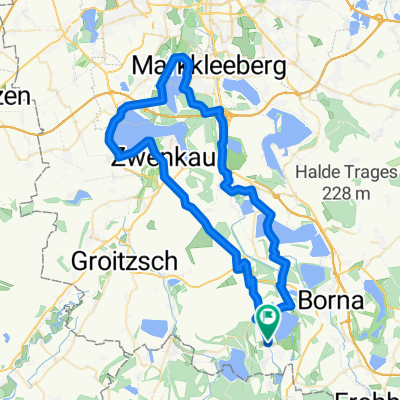
- Neukier.-Zwenkau-Pleißetal
- Distance
- 65.9 km
- Ascent
- 90 m
- Descent
- 93 m
- Location
- Regis-Breitingen, Saxony, Germany
- Pleißental und Schnaudertal
- Distance
- 82.8 km
- Ascent
- 291 m
- Descent
- 291 m
- Location
- Regis-Breitingen, Saxony, Germany
- Lucka-Groitzsch-Großstolpen-Lucka
- Distance
- 36 km
- Ascent
- 86 m
- Descent
- 87 m
- Location
- Regis-Breitingen, Saxony, Germany
- Pleißenaue
- Distance
- 27.4 km
- Ascent
- 124 m
- Descent
- 124 m
- Location
- Regis-Breitingen, Saxony, Germany
- Meuselw.-Haynsburg-B.Köstr.-Kayna
- Distance
- 113.9 km
- Ascent
- 498 m
- Descent
- 498 m
- Location
- Regis-Breitingen, Saxony, Germany
- Schnaudertal-Luckaer Forst-Haselbacher See
- Distance
- 46.4 km
- Ascent
- 138 m
- Descent
- 138 m
- Location
- Regis-Breitingen, Saxony, Germany
- Hasselbacher See - Grillensee
- Distance
- 46.2 km
- Ascent
- 211 m
- Descent
- 251 m
- Location
- Regis-Breitingen, Saxony, Germany
Open it in the app