

20160328
A cycling route starting in Naka, Ibaraki, Japan.
Overview
About this route
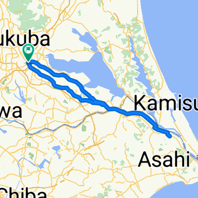
tsukuba-tsuchiura-kasumigaura-ishioka-kasumigaura-tsuchiura-tsukuba
- -:--
- Duration
- 45.2 km
- Distance
- 186 m
- Ascent
- 188 m
- Descent
- ---
- Avg. speed
- ---
- Max. altitude
Continue with Bikemap
Use, edit, or download this cycling route
You would like to ride 20160328 or customize it for your own trip? Here is what you can do with this Bikemap route:
Free features
- Save this route as favorite or in collections
- Copy & plan your own version of this route
- Sync your route with Garmin or Wahoo
Premium features
Free trial for 3 days, or one-time payment. More about Bikemap Premium.
- Navigate this route on iOS & Android
- Export a GPX / KML file of this route
- Create your custom printout (try it for free)
- Download this route for offline navigation
Discover more Premium features.
Get Bikemap PremiumFrom our community
Other popular routes starting in Naka
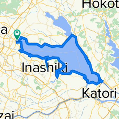
 20160327
- Distance
- 119.5 km
- Ascent
- 118 m
- Descent
- 117 m
- Location
- Naka, Ibaraki, Japan
 20160328
- Distance
- 45.2 km
- Ascent
- 186 m
- Descent
- 188 m
- Location
- Naka, Ibaraki, Japan
 Tsukuba to Oma
- Distance
- 1,133.9 km
- Ascent
- 5,129 m
- Descent
- 5,158 m
- Location
- Naka, Ibaraki, Japan
 川口2丁目, 土浦市へ川口2丁目, 土浦市
- Distance
- 95.9 km
- Ascent
- 70 m
- Descent
- 67 m
- Location
- Naka, Ibaraki, Japan
 20161214
- Distance
- 40.1 km
- Ascent
- 114 m
- Descent
- 114 m
- Location
- Naka, Ibaraki, Japan
 霞ヶ浦1周ショートコース
- Distance
- 99.5 km
- Ascent
- 38 m
- Descent
- 47 m
- Location
- Naka, Ibaraki, Japan
 20160402
- Distance
- 121.1 km
- Ascent
- 76 m
- Descent
- 75 m
- Location
- Naka, Ibaraki, Japan
 20160320
- Distance
- 70.6 km
- Ascent
- 142 m
- Descent
- 142 m
- Location
- Naka, Ibaraki, Japan
Open it in the app