

Las Zomas. La Mota
A cycling route starting in Cuenca, Castille-La Mancha, Spain.
Overview
About this route
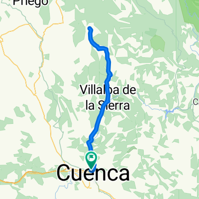
Route to the Zomas, skirting the Sierra de la Pila via trails and returning along the Río Moscas and the house of La Mota.
- -:--
- Duration
- 42.6 km
- Distance
- 517 m
- Ascent
- 516 m
- Descent
- ---
- Avg. speed
- ---
- Max. altitude
Route highlights
Points of interest along the route
Point of interest after 2 km
Fuente de el Canto
Point of interest after 6.9 km
Cruzamos la Senda del Vallejo de la Zorra
Point of interest after 11.1 km
Barranco del Portillo
Point of interest after 11.5 km
Hoz del Buey
Point of interest after 11.9 km
Hoz Chiquilla
Point of interest after 13.7 km
Hoz de San Miguel
Point of interest after 15.5 km
Fuente del Royo
Point of interest after 17 km
Viaducto del Tren.
Point of interest after 18.7 km
El Tesoro

Photo after 22.9 km
Iglesia de las Zomas

Photo after 23.2 km
Laguna de las Zomas
Drinking water after 23.9 km
Microrreserva "Complejo Lagunar del Río Moscas"
Point of interest after 25.8 km
se conserva el mayor depósito de fósiles de dinosaurios de Europa occidental.
Point of interest after 30.3 km
Yacimiento Celtíbero

Photo after 36.8 km
Fuente romana de la Mota o Fuente del Sol
Point of interest after 37.4 km
Casa de la Mota

Photo after 37.7 km
Puente Romano de la Mota
Continue with Bikemap
Use, edit, or download this cycling route
You would like to ride Las Zomas. La Mota or customize it for your own trip? Here is what you can do with this Bikemap route:
Free features
- Save this route as favorite or in collections
- Copy & plan your own version of this route
- Sync your route with Garmin or Wahoo
Premium features
Free trial for 3 days, or one-time payment. More about Bikemap Premium.
- Navigate this route on iOS & Android
- Export a GPX / KML file of this route
- Create your custom printout (try it for free)
- Download this route for offline navigation
Discover more Premium features.
Get Bikemap PremiumFrom our community
Other popular routes starting in Cuenca
 Cuenca - Cuevas Velasco - Valdecolmenas - Villarejo Peñuela - Cuenca
- Distance
- 80.7 km
- Ascent
- 879 m
- Descent
- 790 m
- Location
- Cuenca, Castille-La Mancha, Spain
 Vallejo del Pumar
- Distance
- 45.3 km
- Ascent
- 655 m
- Descent
- 654 m
- Location
- Cuenca, Castille-La Mancha, Spain
 Cuenca - Fresneda de Altarejos - Mota - Valdeganga - Tórtola - Cuenca
- Distance
- 75.3 km
- Ascent
- 737 m
- Descent
- 707 m
- Location
- Cuenca, Castille-La Mancha, Spain
 Primer tramo Maraton "Sendas de Cuenca"
- Distance
- 37.7 km
- Ascent
- 668 m
- Descent
- 670 m
- Location
- Cuenca, Castille-La Mancha, Spain
 Cuenca - Villalba - Fresneda - Villalba - Cuenca
- Distance
- 85.1 km
- Ascent
- 813 m
- Descent
- 790 m
- Location
- Cuenca, Castille-La Mancha, Spain
 Carrera Montana de Jabaga en Bici
- Distance
- 51.9 km
- Ascent
- 811 m
- Descent
- 811 m
- Location
- Cuenca, Castille-La Mancha, Spain
 Palomera, Buenache de la Sierra, Valdecabras.
- Distance
- 52.8 km
- Ascent
- 612 m
- Descent
- 613 m
- Location
- Cuenca, Castille-La Mancha, Spain
 Cabeza Mosilla
- Distance
- 42.5 km
- Ascent
- 884 m
- Descent
- 884 m
- Location
- Cuenca, Castille-La Mancha, Spain
Open it in the app