

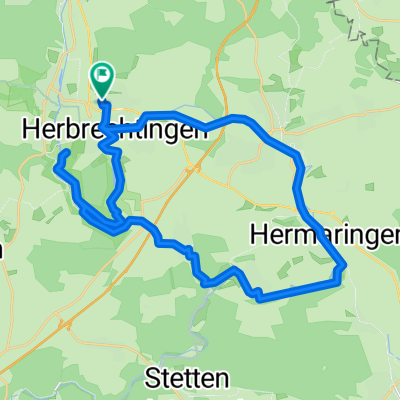
Hausstrecke 1
A cycling route starting in Herbrechtingen, Baden-Wurttemberg, Germany.
Overview
About this route
RW26-Giengen-Hermaringen-Hürben-Anhausen- RW26
- -:--
- Duration
- 28.5 km
- Distance
- 267 m
- Ascent
- 267 m
- Descent
- ---
- Avg. speed
- ---
- Max. altitude
Route quality
Waytypes & surfaces along the route
Waytypes
Quiet road
15.7 km
(55 %)
Track
8.8 km
(31 %)
Surfaces
Paved
19.1 km
(67 %)
Unpaved
7.7 km
(27 %)
Asphalt
17.7 km
(62 %)
Loose gravel
3.7 km
(13 %)
Continue with Bikemap
Use, edit, or download this cycling route
You would like to ride Hausstrecke 1 or customize it for your own trip? Here is what you can do with this Bikemap route:
Free features
- Save this route as favorite or in collections
- Copy & plan your own version of this route
- Sync your route with Garmin or Wahoo
Premium features
Free trial for 3 days, or one-time payment. More about Bikemap Premium.
- Navigate this route on iOS & Android
- Export a GPX / KML file of this route
- Create your custom printout (try it for free)
- Download this route for offline navigation
Discover more Premium features.
Get Bikemap PremiumFrom our community
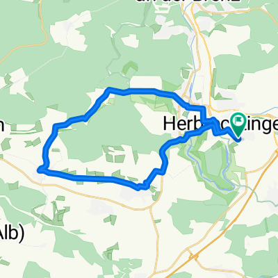
Other popular routes starting in Herbrechtingen
 Herbrechtingen-Hürben Eselsburg
- Distance
- 31.9 km
- Ascent
- 309 m
- Descent
- 327 m
- Location
- Herbrechtingen, Baden-Wurttemberg, Germany
 Eselsburger Tal Runde 32km
- Distance
- 46.8 km
- Ascent
- 228 m
- Descent
- 304 m
- Location
- Herbrechtingen, Baden-Wurttemberg, Germany
 Radrunde durch Herbrechtingen
- Distance
- 24 km
- Ascent
- 257 m
- Descent
- 261 m
- Location
- Herbrechtingen, Baden-Wurttemberg, Germany
 Herbrechtingen - Anhauser Tal - Lonetal - Kagberg - Herbrechtingen
- Distance
- 30 km
- Ascent
- 432 m
- Descent
- 431 m
- Location
- Herbrechtingen, Baden-Wurttemberg, Germany
 Eselsburger Tal Rundweg
- Distance
- 10 km
- Ascent
- 235 m
- Descent
- 235 m
- Location
- Herbrechtingen, Baden-Wurttemberg, Germany
 E-Biken in der Schwäbischen Albregion
- Distance
- 29.5 km
- Ascent
- 354 m
- Descent
- 337 m
- Location
- Herbrechtingen, Baden-Wurttemberg, Germany
 Beethovenweg nach Bahnhof
- Distance
- 44.2 km
- Ascent
- 133 m
- Descent
- 283 m
- Location
- Herbrechtingen, Baden-Wurttemberg, Germany
 Eselsburger Tal Runde 32km
- Distance
- 32.7 km
- Ascent
- 313 m
- Descent
- 313 m
- Location
- Herbrechtingen, Baden-Wurttemberg, Germany
Open it in the app