

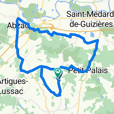
IGLESIAS Y CHATEAUX EN LUSSACAIS
A cycling route starting in Lussac, Nouvelle-Aquitaine, France.
Overview
About this route
CHURCHES AND CHATEAUX IN LUSSACAIS
- -:--
- Duration
- 33.5 km
- Distance
- 292 m
- Ascent
- 292 m
- Descent
- ---
- Avg. speed
- ---
- Max. altitude

Route quality
Waytypes & surfaces along the route
Waytypes
Quiet road
20.4 km
(61 %)
Road
11.7 km
(35 %)
Undefined
1.3 km
(4 %)
Surfaces
Paved
11.4 km
(34 %)
Asphalt
11.4 km
(34 %)
Undefined
22.1 km
(66 %)
Continue with Bikemap
Use, edit, or download this cycling route
You would like to ride IGLESIAS Y CHATEAUX EN LUSSACAIS or customize it for your own trip? Here is what you can do with this Bikemap route:
Free features
- Save this route as favorite or in collections
- Copy & plan your own version of this route
- Sync your route with Garmin or Wahoo
Premium features
Free trial for 3 days, or one-time payment. More about Bikemap Premium.
- Navigate this route on iOS & Android
- Export a GPX / KML file of this route
- Create your custom printout (try it for free)
- Download this route for offline navigation
Discover more Premium features.
Get Bikemap PremiumFrom our community
Other popular routes starting in Lussac
 IGLESIAS Y CHATEAUX EN LUSSACAIS
- Distance
- 33.5 km
- Ascent
- 292 m
- Descent
- 292 m
- Location
- Lussac, Nouvelle-Aquitaine, France
 Ride One
- Distance
- 51.4 km
- Ascent
- 408 m
- Descent
- 409 m
- Location
- Lussac, Nouvelle-Aquitaine, France
 Les Salles-de-Castillon
- Distance
- 40.1 km
- Ascent
- 434 m
- Descent
- 434 m
- Location
- Lussac, Nouvelle-Aquitaine, France
 De D123, Saint-Cibard à Rue Pierre Augereau 30, Camps-sur-l'Isle
- Distance
- 58.4 km
- Ascent
- 425 m
- Descent
- 510 m
- Location
- Lussac, Nouvelle-Aquitaine, France
 Fleur de Roques _ Saint-Emilion
- Distance
- 22.8 km
- Ascent
- 219 m
- Descent
- 306 m
- Location
- Lussac, Nouvelle-Aquitaine, France
 De Mayne Blanc à Mayne Blanc
- Distance
- 25.6 km
- Ascent
- 198 m
- Descent
- 197 m
- Location
- Lussac, Nouvelle-Aquitaine, France
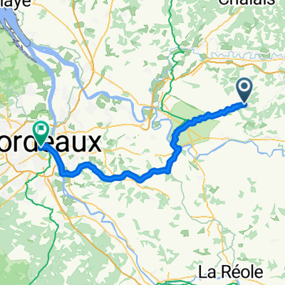 Lussac - Bordeaux
- Distance
- 68.5 km
- Ascent
- 494 m
- Descent
- 539 m
- Location
- Lussac, Nouvelle-Aquitaine, France
Open it in the app