

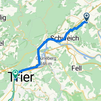
Bekond - Schweich - Thörnicher Ritsch - Bekond
A cycling route starting in Bekond, Rhineland-Palatinate, Germany.
Overview
About this route
A lap along the Moselle on a racing bike
- -:--
- Duration
- 24.2 km
- Distance
- 187 m
- Ascent
- 198 m
- Descent
- ---
- Avg. speed
- ---
- Max. altitude
Route quality
Waytypes & surfaces along the route
Waytypes
Path
8.9 km
(37 %)
Track
3.6 km
(15 %)
Surfaces
Paved
23 km
(95 %)
Asphalt
22.5 km
(93 %)
Paved (undefined)
0.5 km
(2 %)
Undefined
1.2 km
(5 %)
Continue with Bikemap
Use, edit, or download this cycling route
You would like to ride Bekond - Schweich - Thörnicher Ritsch - Bekond or customize it for your own trip? Here is what you can do with this Bikemap route:
Free features
- Save this route as favorite or in collections
- Copy & plan your own version of this route
- Sync your route with Garmin or Wahoo
Premium features
Free trial for 3 days, or one-time payment. More about Bikemap Premium.
- Navigate this route on iOS & Android
- Export a GPX / KML file of this route
- Create your custom printout (try it for free)
- Download this route for offline navigation
Discover more Premium features.
Get Bikemap PremiumFrom our community
Other popular routes starting in Bekond
 Moselstraße 55A, Bekond nach Mehring
- Distance
- 14.5 km
- Ascent
- 149 m
- Descent
- 164 m
- Location
- Bekond, Rhineland-Palatinate, Germany
 Bekond-Meulenwald-Quint-Schweich-Bekond
- Distance
- 31.7 km
- Ascent
- 673 m
- Descent
- 674 m
- Location
- Bekond, Rhineland-Palatinate, Germany
 Kieskaule und Mosel Tour
- Distance
- 32.5 km
- Ascent
- 244 m
- Descent
- 240 m
- Location
- Bekond, Rhineland-Palatinate, Germany
 Route nach Hochkreuz 1, 54343 Föhren
- Distance
- 0.9 km
- Ascent
- 4 m
- Descent
- 0 m
- Location
- Bekond, Rhineland-Palatinate, Germany
 Bekond - Schweich - Thörnicher Ritsch - Bekond
- Distance
- 24.2 km
- Ascent
- 187 m
- Descent
- 198 m
- Location
- Bekond, Rhineland-Palatinate, Germany
 Bekond nach Irminenfreihof, Trier
- Distance
- 21.5 km
- Ascent
- 194 m
- Descent
- 274 m
- Location
- Bekond, Rhineland-Palatinate, Germany
 Kieskaule
- Distance
- 11.5 km
- Ascent
- 96 m
- Descent
- 96 m
- Location
- Bekond, Rhineland-Palatinate, Germany
 Moselstraße 55A, Bekond nach Moselstraße 55, Bekond
- Distance
- 25.6 km
- Ascent
- 487 m
- Descent
- 488 m
- Location
- Bekond, Rhineland-Palatinate, Germany
Open it in the app