

perm Bockwindmühle
A cycling route starting in Westend, State of Berlin, Germany.
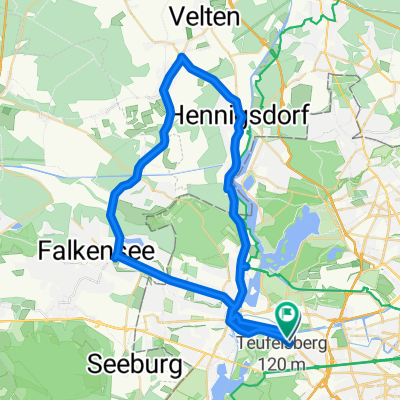
Overview
About this route
permanente RTF
RV Berlin 1888 e.V.
teilweise neue Streckenführung ab 2010
- -:--
- Duration
- 74.2 km
- Distance
- 304 m
- Ascent
- 330 m
- Descent
- ---
- Avg. speed
- 69 m
- Max. altitude

Route quality
Waytypes & surfaces along the route
Waytypes
Road
18.9 km
(25 %)
Path
16.7 km
(23 %)
Surfaces
Paved
68.5 km
(92 %)
Unpaved
0.6 km
(<1 %)
Asphalt
58.6 km
(79 %)
Paving stones
7 km
(9 %)
Continue with Bikemap
Use, edit, or download this cycling route
You would like to ride perm Bockwindmühle or customize it for your own trip? Here is what you can do with this Bikemap route:
Free features
- Save this route as favorite or in collections
- Copy & plan your own version of this route
- Sync your route with Garmin or Wahoo
Premium features
Free trial for 3 days, or one-time payment. More about Bikemap Premium.
- Navigate this route on iOS & Android
- Export a GPX / KML file of this route
- Create your custom printout (try it for free)
- Download this route for offline navigation
Discover more Premium features.
Get Bikemap PremiumFrom our community
Other popular routes starting in Westend
 Tannenbergallee 12, Берлин до Charlottenburg-Wilmersdorf, Берлин
- Distance
- 9.5 km
- Ascent
- 169 m
- Descent
- 169 m
- Location
- Westend, State of Berlin, Germany
 Sacrow Runde
- Distance
- 67.7 km
- Ascent
- 146 m
- Descent
- 161 m
- Location
- Westend, State of Berlin, Germany
 Berlin Havel-Rundtour mit Spandau
- Distance
- 47.9 km
- Ascent
- 251 m
- Descent
- 251 m
- Location
- Westend, State of Berlin, Germany
 Der Alt-Berliner-Klassiker
- Distance
- 45.2 km
- Ascent
- 269 m
- Descent
- 269 m
- Location
- Westend, State of Berlin, Germany
 Feierabendrunde Sacrow/Tegel
- Distance
- 79.6 km
- Ascent
- 246 m
- Descent
- 267 m
- Location
- Westend, State of Berlin, Germany
 Sacrower Runde
- Distance
- 56.2 km
- Ascent
- 326 m
- Descent
- 326 m
- Location
- Westend, State of Berlin, Germany
 perm Bockwindmühle
- Distance
- 74.2 km
- Ascent
- 304 m
- Descent
- 330 m
- Location
- Westend, State of Berlin, Germany
 50 Km Spandau - Schönheide - Tegel - Spandau
- Distance
- 49.6 km
- Ascent
- 89 m
- Descent
- 99 m
- Location
- Westend, State of Berlin, Germany
Open it in the app