
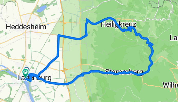
Ladenburg - Rippenweier - Schriesheim - Ladenburg
A cycling route starting in Ladenburg, Baden-Wurttemberg, Germany.
Overview
About this route
Ladenburg - Heiligkreuz - Rippenweier - Ursenbach - Schriesheim - Ladenburg
- -:--
- Duration
- 27.6 km
- Distance
- 495 m
- Ascent
- 495 m
- Descent
- ---
- Avg. speed
- 420 m
- Max. altitude
Route quality
Waytypes & surfaces along the route
Waytypes
Road
6.6 km
(24 %)
Quiet road
5.5 km
(20 %)
Surfaces
Paved
26.3 km
(95 %)
Unpaved
0.8 km
(3 %)
Asphalt
25.4 km
(92 %)
Paved (undefined)
0.8 km
(3 %)
Continue with Bikemap
Use, edit, or download this cycling route
You would like to ride Ladenburg - Rippenweier - Schriesheim - Ladenburg or customize it for your own trip? Here is what you can do with this Bikemap route:
Free features
- Save this route as favorite or in collections
- Copy & plan your own version of this route
- Sync your route with Garmin or Wahoo
Premium features
Free trial for 3 days, or one-time payment. More about Bikemap Premium.
- Navigate this route on iOS & Android
- Export a GPX / KML file of this route
- Create your custom printout (try it for free)
- Download this route for offline navigation
Discover more Premium features.
Get Bikemap PremiumFrom our community
Other popular routes starting in Ladenburg
 Rundtour Odenwald (Weißer Stein, HKS, Altenbach) CLONED FROM ROUTE 271408
- Distance
- 62.4 km
- Ascent
- 880 m
- Descent
- 880 m
- Location
- Ladenburg, Baden-Wurttemberg, Germany
 Ladenburg - HP-Juhöhe-Birkenau-Ober Absteinach-Vorderh.-Ladenburg
- Distance
- 76.7 km
- Ascent
- 816 m
- Descent
- 816 m
- Location
- Ladenburg, Baden-Wurttemberg, Germany
 Plateau Runde
- Distance
- 97.1 km
- Ascent
- 1,412 m
- Descent
- 1,412 m
- Location
- Ladenburg, Baden-Wurttemberg, Germany
 LadenburgHD
- Distance
- 28.1 km
- Ascent
- 35 m
- Descent
- 35 m
- Location
- Ladenburg, Baden-Wurttemberg, Germany
 Ladenburg-Hockenheimring-Speyer-Welde-Ladenburg
- Distance
- 65 km
- Ascent
- 55 m
- Descent
- 57 m
- Location
- Ladenburg, Baden-Wurttemberg, Germany
 Rundtour Odenwald (Weißer Stein, HKS, Altenbach)
- Distance
- 43.5 km
- Ascent
- 696 m
- Descent
- 698 m
- Location
- Ladenburg, Baden-Wurttemberg, Germany
 Trajanstraße 91, Ladenburg nach Max-Planck-Straße 21A, Oftersheim
- Distance
- 16 km
- Ascent
- 0 m
- Descent
- 3 m
- Location
- Ladenburg, Baden-Wurttemberg, Germany
 Armandos flache Runde 75 KM
- Distance
- 74.4 km
- Ascent
- 48 m
- Descent
- 47 m
- Location
- Ladenburg, Baden-Wurttemberg, Germany
Open it in the app