

Ringenhain-Hochkirch-Ringenhain
A cycling route starting in Steinigtwolmsdorf, Saxony, Germany.
Overview
About this route
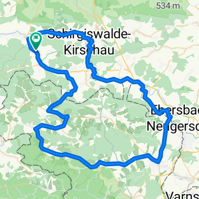
Von Ringenhain gleich zu Beginn bergauf nach Weifa. Schöne Abfahrt hinunter nach Schirgiswalde. Von dort über Kirschau und Rodewitz nach Cunewalde. Über eine steile Rampe hinauf zum Döhlener Berg. Über mehrere Hügel weiter nach Hochkirch. Auf dem Radweg parallel zur B6 nach Plotzen und danach rechts weg nach Lehn. Über einen Anstieg nach Großdehsa und weiter nach Cunewalde. Über Rodewitz, Wilthen und Neukirch zurück nach Ringenhain.
- -:--
- Duration
- 57.6 km
- Distance
- 712 m
- Ascent
- 735 m
- Descent
- ---
- Avg. speed
- 463 m
- Max. altitude

Route quality
Waytypes & surfaces along the route
Waytypes
Busy road
31.7 km
(55 %)
Road
14.9 km
(26 %)
Surfaces
Paved
50 km
(87 %)
Unpaved
0.1 km
(<1 %)
Asphalt
48.2 km
(84 %)
Paved (undefined)
1.9 km
(3 %)
Continue with Bikemap
Use, edit, or download this cycling route
You would like to ride Ringenhain-Hochkirch-Ringenhain or customize it for your own trip? Here is what you can do with this Bikemap route:
Free features
- Save this route as favorite or in collections
- Copy & plan your own version of this route
- Sync your route with Garmin or Wahoo
Premium features
Free trial for 3 days, or one-time payment. More about Bikemap Premium.
- Navigate this route on iOS & Android
- Export a GPX / KML file of this route
- Create your custom printout (try it for free)
- Download this route for offline navigation
Discover more Premium features.
Get Bikemap PremiumFrom our community
Other popular routes starting in Steinigtwolmsdorf
 Wesenitz
- Distance
- 57 km
- Ascent
- 231 m
- Descent
- 500 m
- Location
- Steinigtwolmsdorf, Saxony, Germany
 cesta na jih
- Distance
- 391 km
- Ascent
- 1,580 m
- Descent
- 1,291 m
- Location
- Steinigtwolmsdorf, Saxony, Germany
 Dresden - Tsch. - Oberlausitz
- Distance
- 62.3 km
- Ascent
- 312 m
- Descent
- 583 m
- Location
- Steinigtwolmsdorf, Saxony, Germany
 Rund um den Kottmar
- Distance
- 74 km
- Ascent
- 708 m
- Descent
- 758 m
- Location
- Steinigtwolmsdorf, Saxony, Germany
 Oberlausitzer Runde
- Distance
- 58.8 km
- Ascent
- 433 m
- Descent
- 445 m
- Location
- Steinigtwolmsdorf, Saxony, Germany
 Rund um die Mandau-Quelle
- Distance
- 78.2 km
- Ascent
- 645 m
- Descent
- 629 m
- Location
- Steinigtwolmsdorf, Saxony, Germany
 Po Šluknovsku
- Distance
- 32.2 km
- Ascent
- 418 m
- Descent
- 418 m
- Location
- Steinigtwolmsdorf, Saxony, Germany
 Rund um Fugau
- Distance
- 66.2 km
- Ascent
- 448 m
- Descent
- 448 m
- Location
- Steinigtwolmsdorf, Saxony, Germany
Open it in the app