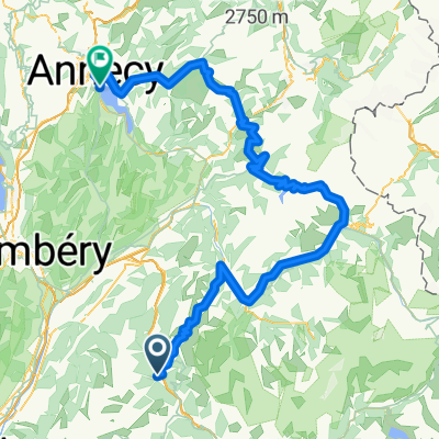
Montarlot 3 juni 2007
A cycling route starting in Saint-Etienne-de-Cuines, Auvergne-Rh么ne-Alpes, France.
Overview
About this route
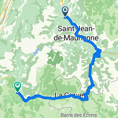
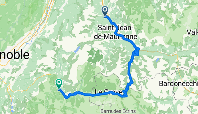
Montarlot - Saint-Jean-de-Maurienne - Saint-Michel-de-Maurienne - Col du T茅l茅graphe - Col du Galibier - Col du Lautaret - Le Bourg-d麓Oisans
- -:--
- Duration
- 108 km
- Distance
- 2,354 m
- Ascent
- 2,207 m
- Descent
- ---
- Avg. speed
- ---
- Max. altitude
Route quality
Waytypes & surfaces along the route
Waytypes
Quiet road
2.2 km
(2 %)
Access road
1.1 km
(1 %)
Undefined
104.8 km
(97 %)
Surfaces
Paved
90.7 km
(84 %)
Asphalt
90.7 km
(84 %)
Undefined
17.3 km
(16 %)
Continue with Bikemap
Use, edit, or download this cycling route
You would like to ride Montarlot 3 juni 2007 or customize it for your own trip? Here is what you can do with this Bikemap route:
Free features
- Save this route as favorite or in collections
- Copy & plan your own version of this route
- Split it into stages to create a multi-day tour
- Sync your route with Garmin or Wahoo
Premium features
Free trial for 3 days, or one-time payment. More about Bikemap Premium.
- Navigate this route on iOS & Android
- Export a GPX / KML file of this route
- Create your custom printout (try it for free)
- Download this route for offline navigation
Discover more Premium features.
Get Bikemap PremiumFrom our community
Other popular routes starting in Saint-Etienne-de-Cuines
1003000St Etienne Cuines- Distance
- 100.2 km
- Ascent
- 2,984 m
- Descent
- 2,983 m
- Location
- Saint-Etienne-de-Cuines, Auvergne-Rh么ne-Alpes, France
Madeleine und Chaussy- Distance
- 72.3 km
- Ascent
- 2,259 m
- Descent
- 2,275 m
- Location
- Saint-Etienne-de-Cuines, Auvergne-Rh么ne-Alpes, France
Col de la Croix de Fer- Distance
- 71.9 km
- Ascent
- 1,963 m
- Descent
- 1,963 m
- Location
- Saint-Etienne-de-Cuines, Auvergne-Rh么ne-Alpes, France
More Recon- Distance
- 43.2 km
- Ascent
- 2,645 m
- Descent
- 2,632 m
- Location
- Saint-Etienne-de-Cuines, Auvergne-Rh么ne-Alpes, France
Glandon Croix de Fer- Distance
- 69.3 km
- Ascent
- 2,006 m
- Descent
- 2,008 m
- Location
- Saint-Etienne-de-Cuines, Auvergne-Rh么ne-Alpes, France
Montarlot 2 juni 2007- Distance
- 41.5 km
- Ascent
- 1,308 m
- Descent
- 1,308 m
- Location
- Saint-Etienne-de-Cuines, Auvergne-Rh么ne-Alpes, France
5-ANNECY- Distance
- 129.9 km
- Ascent
- 2,314 m
- Descent
- 2,273 m
- Location
- Saint-Etienne-de-Cuines, Auvergne-Rh么ne-Alpes, France
St盲fa - Tarifa Stage #4 Sainte Marie de Cuines - L'Alpe d'Huez - Le Bourg de Oisans- Distance
- 84.5 km
- Ascent
- 2,558 m
- Descent
- 2,324 m
- Location
- Saint-Etienne-de-Cuines, Auvergne-Rh么ne-Alpes, France
Open it in the app


