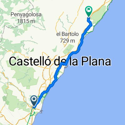
Sagunto-La Llosa
A cycling route starting in Sagunto, Valencia, Spain.
Overview
About this route
Ruta BTT Sagunto-La Llosa
- -:--
- Duration
- 34.8 km
- Distance
- 177 m
- Ascent
- 179 m
- Descent
- ---
- Avg. speed
- ---
- Avg. speed
Route quality
Waytypes & surfaces along the route
Waytypes
Quiet road
25.1 km
(72 %)
Cycleway
3.2 km
(9 %)
Surfaces
Paved
16.1 km
(46 %)
Unpaved
0.1 km
(<1 %)
Asphalt
14.3 km
(41 %)
Paved (undefined)
1.7 km
(5 %)
Route highlights
Points of interest along the route
Point of interest after 19 km
Bar-Restaurante El Carcau
Continue with Bikemap
Use, edit, or download this cycling route
You would like to ride Sagunto-La Llosa or customize it for your own trip? Here is what you can do with this Bikemap route:
Free features
- Save this route as favorite or in collections
- Copy & plan your own version of this route
- Sync your route with Garmin or Wahoo
Premium features
Free trial for 3 days, or one-time payment. More about Bikemap Premium.
- Navigate this route on iOS & Android
- Export a GPX / KML file of this route
- Create your custom printout (try it for free)
- Download this route for offline navigation
Discover more Premium features.
Get Bikemap PremiumFrom our community
Other popular routes starting in Sagunto
- Sagunto - La Llosa - Playa de Almenara
- Distance
- 36.5 km
- Ascent
- 165 m
- Descent
- 167 m
- Location
- Sagunto, Valencia, Spain
- Sagunt, Petrés, bosque ,sendas, fuente, barranco y Castillo
- Distance
- 21.8 km
- Ascent
- 445 m
- Descent
- 446 m
- Location
- Sagunto, Valencia, Spain
- sagunto-codoval-la catalana-quart V.-sagunto
- Distance
- 33.5 km
- Ascent
- 676 m
- Descent
- 625 m
- Location
- Sagunto, Valencia, Spain
- Sagunto-La Llosa
- Distance
- 34.8 km
- Ascent
- 177 m
- Descent
- 179 m
- Location
- Sagunto, Valencia, Spain
- ALTERNATIVA SIERRA ESPADAN
- Distance
- 79.8 km
- Ascent
- 1,591 m
- Descent
- 1,074 m
- Location
- Sagunto, Valencia, Spain
- Sagunto - Valencia
- Distance
- 43 km
- Ascent
- 58 m
- Descent
- 77 m
- Location
- Sagunto, Valencia, Spain
- Sagunto - Moncofar
- Distance
- 53.3 km
- Ascent
- 58 m
- Descent
- 58 m
- Location
- Sagunto, Valencia, Spain
- Sagunto - Antenas Picayo - Pico Aguila - Mola - Xocainet - Gilet -Sagunto
- Distance
- 34.7 km
- Ascent
- 709 m
- Descent
- 709 m
- Location
- Sagunto, Valencia, Spain
Open it in the app