

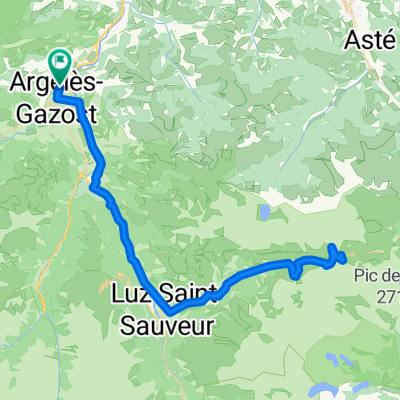
2016 Ride Day 52 - Argelès-Gazost to Bagnères-de-Bigorre
A cycling route starting in Argelès-Gazost, Occitanie, France.
Overview
About this route
This was one wonderful route. First was excellent bike path for maybe 10 km. Then the rest, except for the last kilometer in Bagnères-de-Bigorre, was on D26/D7/D26/D18/D26, all of which was zero traffic road with wonderful scenery and good climbing and descents.
We highly recommend this route.
- -:--
- Duration
- 40.6 km
- Distance
- 540 m
- Ascent
- 523 m
- Descent
- ---
- Avg. speed
- ---
- Max. altitude

Route photos

Route quality
Waytypes & surfaces along the route
Waytypes
Road
23.5 km
(58 %)
Cycleway
8.9 km
(22 %)
Surfaces
Paved
12.6 km
(31 %)
Asphalt
12.6 km
(31 %)
Undefined
28 km
(69 %)
Continue with Bikemap
Use, edit, or download this cycling route
You would like to ride 2016 Ride Day 52 - Argelès-Gazost to Bagnères-de-Bigorre or customize it for your own trip? Here is what you can do with this Bikemap route:
Free features
- Save this route as favorite or in collections
- Copy & plan your own version of this route
- Sync your route with Garmin or Wahoo
Premium features
Free trial for 3 days, or one-time payment. More about Bikemap Premium.
- Navigate this route on iOS & Android
- Export a GPX / KML file of this route
- Create your custom printout (try it for free)
- Download this route for offline navigation
Discover more Premium features.
Get Bikemap PremiumFrom our community
Other popular routes starting in Argelès-Gazost
 Pirineos Spandelle-Aubisque
- Distance
- 79.2 km
- Ascent
- 2,607 m
- Descent
- 2,605 m
- Location
- Argelès-Gazost, Occitanie, France
 V13 Col de Couraduque
- Distance
- 16.3 km
- Ascent
- 963 m
- Descent
- 40 m
- Location
- Argelès-Gazost, Occitanie, France
 Aubisque
- Distance
- 29.1 km
- Ascent
- 1,533 m
- Descent
- 273 m
- Location
- Argelès-Gazost, Occitanie, France
 Argeles-Gazost- Lanus
- Distance
- 114.3 km
- Ascent
- 3,302 m
- Descent
- 3,296 m
- Location
- Argelès-Gazost, Occitanie, France
 R4K PC2012 Dag 1 middag
- Distance
- 37.4 km
- Ascent
- 1,245 m
- Descent
- 1,244 m
- Location
- Argelès-Gazost, Occitanie, France
 Argelès-Gazost - cirque de Troumousse - Argelès-Gazost
- Distance
- 117.9 km
- Ascent
- 2,264 m
- Descent
- 2,264 m
- Location
- Argelès-Gazost, Occitanie, France
 R4K PC2012 Dag 3 groep B
- Distance
- 76.7 km
- Ascent
- 1,736 m
- Descent
- 1,736 m
- Location
- Argelès-Gazost, Occitanie, France
 Pirenaica11. Agos-Vidalos - Luz-Saint-Sauveur
- Distance
- 121 km
- Ascent
- 3,391 m
- Descent
- 3,074 m
- Location
- Argelès-Gazost, Occitanie, France
Open it in the app