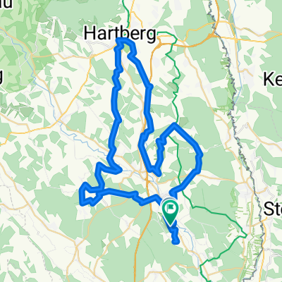
nörning-hartl-hoffkirchen-dienersdorf-Hochszrasse-unterdombach-wenireith-buch
A cycling route starting in Bad Waltersdorf, Styria, Austria.
Overview
About this route
- 1 h 42 min
- Duration
- 42.2 km
- Distance
- 415 m
- Ascent
- 415 m
- Descent
- 24.9 km/h
- Avg. speed
- ---
- Max. altitude
Route quality
Waytypes & surfaces along the route
Waytypes
Quiet road
21.6 km
(51 %)
Busy road
10.2 km
(24 %)
Surfaces
Paved
4.6 km
(11 %)
Asphalt
4.6 km
(11 %)
Undefined
37.6 km
(89 %)
Continue with Bikemap
Use, edit, or download this cycling route
You would like to ride nörning-hartl-hoffkirchen-dienersdorf-Hochszrasse-unterdombach-wenireith-buch or customize it for your own trip? Here is what you can do with this Bikemap route:
Free features
- Save this route as favorite or in collections
- Copy & plan your own version of this route
- Sync your route with Garmin or Wahoo
Premium features
Free trial for 3 days, or one-time payment. More about Bikemap Premium.
- Navigate this route on iOS & Android
- Export a GPX / KML file of this route
- Create your custom printout (try it for free)
- Download this route for offline navigation
Discover more Premium features.
Get Bikemap PremiumFrom our community
Other popular routes starting in Bad Waltersdorf
- Morning Dew Ride - Bad Waltersdorf
- Distance
- 45 km
- Ascent
- 791 m
- Descent
- 838 m
- Location
- Bad Waltersdorf, Styria, Austria
- Bad Waltersdorf - Deutsch Kaltenbrunn - Runde
- Distance
- 39.9 km
- Ascent
- 274 m
- Descent
- 274 m
- Location
- Bad Waltersdorf, Styria, Austria
- Pressereise 12.05.2015
- Distance
- 30.9 km
- Ascent
- 150 m
- Descent
- 145 m
- Location
- Bad Waltersdorf, Styria, Austria
- St. Magdalena Radweg R36, Ausgangspunkt Steirerhof
- Distance
- 16.2 km
- Ascent
- 290 m
- Descent
- 291 m
- Location
- Bad Waltersdorf, Styria, Austria
- Bad Waltersdorf
- Distance
- 37.2 km
- Ascent
- 439 m
- Descent
- 430 m
- Location
- Bad Waltersdorf, Styria, Austria
- Radtour ins Lafnitztal
- Distance
- 26.8 km
- Ascent
- 186 m
- Descent
- 187 m
- Location
- Bad Waltersdorf, Styria, Austria
- Bad Waltersdorf - Wien City
- Distance
- 145.9 km
- Ascent
- 1,130 m
- Descent
- 1,215 m
- Location
- Bad Waltersdorf, Styria, Austria
- Hartberg Bad Waltersdorf, 17. August 2013 Straßenrennen
- Distance
- 38.4 km
- Ascent
- 287 m
- Descent
- 287 m
- Location
- Bad Waltersdorf, Styria, Austria
Open it in the app