
Naramata Routes
N - L - Naramata Leg Warmer - Competitive
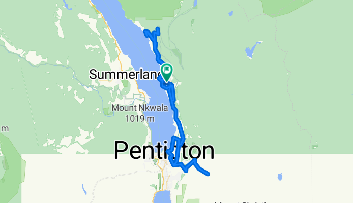
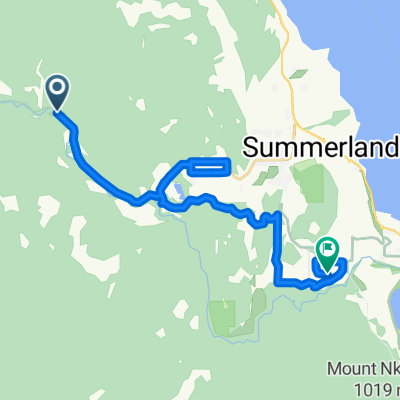
A cycling route starting in Summerland, British Columbia, Canada.
Overview
About this route
This is a great little leg warming route that just happens to go through one of the most picturesque wine regions in the world - the Naramata Bench. This is a great route for groups of varying abilities, as there are three "out and back" options that allow you to add either km's or climbs. We start from Therapy Vineyards and cruise through sleepy little Naramata before a short climb up to North Naramata Road. Here we head out to Chute Lake Road, the first of our optional climbs. It's a gorgeous climb on fresh pavement to a cattle guard where the gravel starts. We turn back and then decide if we want to do the second option, the descent down to Indian Rock by the lake and the climb back up to the road. We then head back to Naramata for our caffeine refueling break (at 30 km) at either the Grape Leaf Bistro or Cafe Never Matters. Then, back to Naramata Road for a gentle roller ride towards Penticton. We have an optional stop at the Bench for another coffee and snack, then it's the character testing final option - just under 500 M of grueling vertical up Carmi Avenue and Beaverdell Road for an amazing viewpoint of the valley below. Conquer that and it's all downhill to lunch at Lakebreeze Winery and a gentle ride back to Therapy Guesthouse.
If you're opting for less vertical and more wine tasting, we delete the 500M climb and hit a few more winery stops on the way back - notably La Frenz - Red Rooster - and Poplar Grove Cheese and Lock & Smith.
- -:--
- Duration
- 78.8 km
- Distance
- 1,435 m
- Ascent
- 1,435 m
- Descent
- ---
- Avg. speed
- ---
- Max. altitude

Part of
3 stages
Route quality
Waytypes & surfaces along the route
Waytypes
Quiet road
34.7 km
(44 %)
Road
24.4 km
(31 %)
Undefined
19.7 km
(25 %)
Surfaces
Paved
27.6 km
(35 %)
Unpaved
7.1 km
(9 %)
Asphalt
20.5 km
(26 %)
Paved (undefined)
7.1 km
(9 %)
Continue with Bikemap
Use, edit, or download this cycling route
You would like to ride N - L - Naramata Leg Warmer - Competitive or customize it for your own trip? Here is what you can do with this Bikemap route:
Free features
- Save this route as favorite or in collections
- Copy & plan your own version of this route
- Sync your route with Garmin or Wahoo
Premium features
Free trial for 3 days, or one-time payment. More about Bikemap Premium.
- Navigate this route on iOS & Android
- Export a GPX / KML file of this route
- Create your custom printout (try it for free)
- Download this route for offline navigation
Discover more Premium features.
Get Bikemap PremiumFrom our community
Other popular routes starting in Summerland
 Chute Lake - Poplar Grove KVR
- Distance
- 39.1 km
- Ascent
- 71 m
- Descent
- 873 m
- Location
- Summerland, British Columbia, Canada
 KVR - Summerland to Hope
- Distance
- 250.4 km
- Ascent
- 1,095 m
- Descent
- 1,575 m
- Location
- Summerland, British Columbia, Canada
 Route in Summerland
- Distance
- 8 km
- Ascent
- 172 m
- Descent
- 156 m
- Location
- Summerland, British Columbia, Canada
 12-09-14 Kanada: Chute Lake Resort (Kettle Valley Rail Trail)-Penticton
- Distance
- 39.6 km
- Ascent
- 19 m
- Descent
- 819 m
- Location
- Summerland, British Columbia, Canada
 N - S - Naramata Leg Warmer
- Distance
- 30.8 km
- Ascent
- 325 m
- Descent
- 325 m
- Location
- Summerland, British Columbia, Canada
 Summerland KVR TCT with notes
- Distance
- 21.2 km
- Ascent
- 291 m
- Descent
- 479 m
- Location
- Summerland, British Columbia, Canada
 Summerland KVR-TCT
- Distance
- 21.4 km
- Ascent
- 304 m
- Descent
- 493 m
- Location
- Summerland, British Columbia, Canada
 N - L - Naramata Loop
- Distance
- 79.1 km
- Ascent
- 1,510 m
- Descent
- 1,510 m
- Location
- Summerland, British Columbia, Canada
Open it in the app