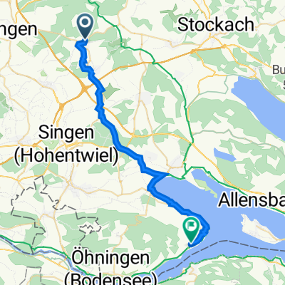
Laufrunde mittel
A cycling route starting in Aach, Baden-Württemberg, Germany.
Overview
About this route
Mittellange Joggingroute mit (bei schönem Wetter) Alpenblick.
- -:--
- Duration
- 5.9 km
- Distance
- 66 m
- Ascent
- 69 m
- Descent
- ---
- Avg. speed
- ---
- Avg. speed
Route quality
Waytypes & surfaces along the route
Waytypes
Track
5.1 km
(86 %)
Quiet road
0.6 km
(10 %)
Access road
0.2 km
(4 %)
Surfaces
Paved
1.6 km
(27 %)
Unpaved
4.1 km
(69 %)
Gravel
4.1 km
(69 %)
Asphalt
1.6 km
(27 %)
Undefined
0.2 km
(4 %)
Continue with Bikemap
Use, edit, or download this cycling route
You would like to ride Laufrunde mittel or customize it for your own trip? Here is what you can do with this Bikemap route:
Free features
- Save this route as favorite or in collections
- Copy & plan your own version of this route
- Sync your route with Garmin or Wahoo
Premium features
Free trial for 3 days, or one-time payment. More about Bikemap Premium.
- Navigate this route on iOS & Android
- Export a GPX / KML file of this route
- Create your custom printout (try it for free)
- Download this route for offline navigation
Discover more Premium features.
Get Bikemap PremiumFrom our community
Other popular routes starting in Aach
- Rennrad Runde
- Distance
- 38.4 km
- Ascent
- 479 m
- Descent
- 479 m
- Location
- Aach, Baden-Württemberg, Germany
- Trainingsrunde für Anja und Fabian
- Distance
- 48.8 km
- Ascent
- 828 m
- Descent
- 828 m
- Location
- Aach, Baden-Württemberg, Germany
- Arbeitsweg
- Distance
- 55.1 km
- Ascent
- 273 m
- Descent
- 310 m
- Location
- Aach, Baden-Württemberg, Germany
- Aachtopf-Radolfzell-Aachtopf
- Distance
- 49 km
- Ascent
- 171 m
- Descent
- 171 m
- Location
- Aach, Baden-Württemberg, Germany
- Kleine Rundfahrt
- Distance
- 111.9 km
- Ascent
- 1,110 m
- Descent
- 1,112 m
- Location
- Aach, Baden-Württemberg, Germany
- Aachquelle - Rheinau
- Distance
- 44.8 km
- Ascent
- 363 m
- Descent
- 469 m
- Location
- Aach, Baden-Württemberg, Germany
- Laufrunde mittel
- Distance
- 5.9 km
- Ascent
- 66 m
- Descent
- 69 m
- Location
- Aach, Baden-Württemberg, Germany
- Route in Aach
- Distance
- 29.1 km
- Ascent
- 568 m
- Descent
- 588 m
- Location
- Aach, Baden-Württemberg, Germany
Open it in the app