

B2B00042 55419 > 55422 via Greenway, Cedar Lake, and Theo Wirth
A cycling route starting in Richfield, Minnesota, United States.
Overview
About this route
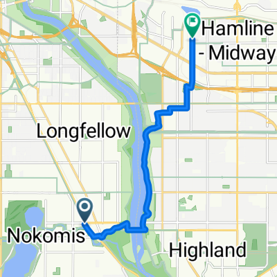
Begin your route by riding north on 3rd Avenue south. At 32nd Street go right for two blocks to 5th Avenue South. Go left on 5th. After Lake street you will come to the Greenway Trail. Get on the trail going west (left). Take this trail all the way to the Dean Parkway exit. Go right on Dean parkway for a few blocks to Cedar Lake Parkway and go left. Follow Cedar Lake parkway all the way around Cedar lake to the stoplight. Veer right and continue on Cedar Lake Parkway, which turns into Theodore Wirth Parkway. Cross over 394 and continue on Theodore Wirth Parkway all the way to Olson Memorial Hwy (55). At Highway 55 you will cross over to the north west corner and walk your bike to the frontage road that runs along the north side of the highway. Follow this frontage road to a righthand turn on Meadow Lane North. Go left on Dahlberg Drive to Olson Hwy Service Road and go right. COntinue on this service road to destination.
- -:--
- Duration
- 13.3 km
- Distance
- 61 m
- Ascent
- 59 m
- Descent
- ---
- Avg. speed
- 289 m
- Max. altitude

Route quality
Waytypes & surfaces along the route
Waytypes
Road
4.5 km
(34 %)
Cycleway
4.3 km
(32 %)
Surfaces
Paved
10 km
(75 %)
Asphalt
8.8 km
(66 %)
Paved (undefined)
0.9 km
(7 %)
Route highlights
Points of interest along the route
Point of interest after 12.2 km
You will need to walk your bike to the frontage road along the north side of Olson Memorial Highway.
Continue with Bikemap
Use, edit, or download this cycling route
You would like to ride B2B00042 55419 > 55422 via Greenway, Cedar Lake, and Theo Wirth or customize it for your own trip? Here is what you can do with this Bikemap route:
Free features
- Save this route as favorite or in collections
- Copy & plan your own version of this route
- Sync your route with Garmin or Wahoo
Premium features
Free trial for 3 days, or one-time payment. More about Bikemap Premium.
- Navigate this route on iOS & Android
- Export a GPX / KML file of this route
- Create your custom printout (try it for free)
- Download this route for offline navigation
Discover more Premium features.
Get Bikemap PremiumFrom our community
Other popular routes starting in Richfield
 Route to Headflyer Brewing
- Distance
- 9.1 km
- Ascent
- 100 m
- Descent
- 69 m
- Location
- Richfield, Minnesota, United States
 B2B00114 55409 >55414 via Park Ave and stone arch bridge
- Distance
- 9 km
- Ascent
- 48 m
- Descent
- 57 m
- Location
- Richfield, Minnesota, United States
 B2B00920 55407>55438 via Portland, Mnnha Pwy, Logan, Hylund Prk
- Distance
- 23.7 km
- Ascent
- 98 m
- Descent
- 95 m
- Location
- Richfield, Minnesota, United States
 the Bike & Bistro's premiere tour
- Distance
- 6.7 km
- Ascent
- 26 m
- Descent
- 9 m
- Location
- Richfield, Minnesota, United States
 MoA - Rosemount - Hastings - South Saint Paul - MoA
- Distance
- 107.8 km
- Ascent
- 347 m
- Descent
- 347 m
- Location
- Richfield, Minnesota, United States
 B2B00814 55409 > 55455 via Park Ave, University Ave SE
- Distance
- 10.1 km
- Ascent
- 57 m
- Descent
- 57 m
- Location
- Richfield, Minnesota, United States
 Day 1 Lag 3
- Distance
- 106.3 km
- Ascent
- 327 m
- Descent
- 359 m
- Location
- Richfield, Minnesota, United States
 East 46th Street 180, Minneapolis to Union Depot, Saint Paul
- Distance
- 22.2 km
- Ascent
- 153 m
- Descent
- 185 m
- Location
- Richfield, Minnesota, United States
Open it in the app